Free CXC Geography Paper 1 May/June 2001 past paper from 2001. Includes a worked answer key. Open the PDF, take a timed test, and study with AI on Caribbean AI.
Answer keys are free on Caribbean AI. View the answers to every past-paper question at no cost - no payment needed - with step-by-step worked solutions and instant AI marking available on Premium.
CSEC Geography Paper 1 May/June 2001 - Free CXC Past Paper with Answers
Free CXC Geography Paper 1 May/June 2001 past paper from 2001. Includes a worked answer key. Open the PDF, take a timed test, and study with AI on Caribbean AI.
Opening the interactive papers…
Every question from this paper as text. See the answers and worked solutions. Questions are the property of the Caribbean Examinations Council; Caribbean AI is not affiliated with CXC.
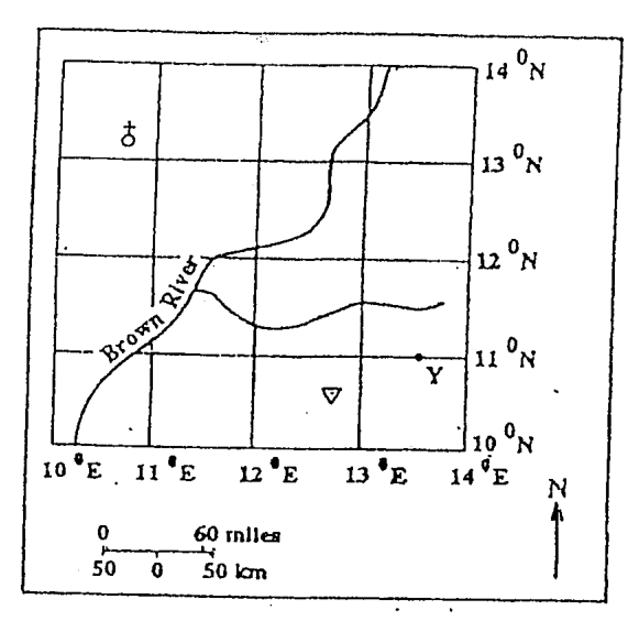
Items 1-4 refer to the following map.
Point Y is located at
13°N 11° 30Έ
14°N 13° 30Ε
11°N 13° 30E
13°N 10° 30Ε
The Brown River is flowing from the
North-west to south-south-east
North-east to south-west
West-south-west to east-south-east
North-east to south-east
The bearing of the trigonometrical station from the church is
30°
45°
160°
340°
The length of the tributary of the Brown River is approximately
480 km (300 miles)
320 km (200 miles)
290 km (180 miles)
250 km (150 miles)
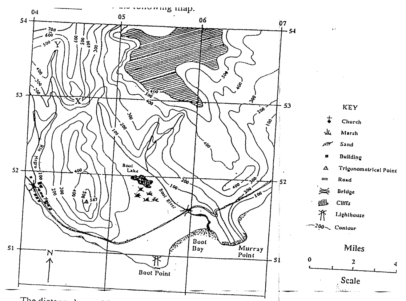
The distance by road from the bridge over Boot River to the church in the village is approximately
4 miles
6 miles
8 miles
10 miles
The feature at grid reference 047516 is a
church
road bridge
beach
trig point
The coastal area at Boot Bay contains
cliffs
marshland
a coral reef
a sand beach
The area shaded on the map represents a
volcano
plateau
plain
valley
The land at Murray Point ends in a
cliff
beach
harbour
marsh
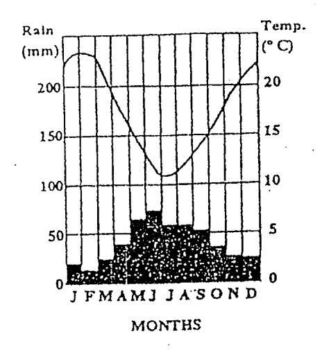
Items 10 12 refer to the following rainfall and temperature graph.
The two wettest months of the year for the station shown above are
January and February
May-and June
July and August
November and December
The annual range of temperature is APPROXIMATELY
3°C
5°C
12°C
19°C
Which of the following statements is true?
The hottest months of the year are also the driest.
The hottest months of the year are also the wettest.
There is little variation in temperature throughout the year.
There is little variation in rainfall throughout the year.
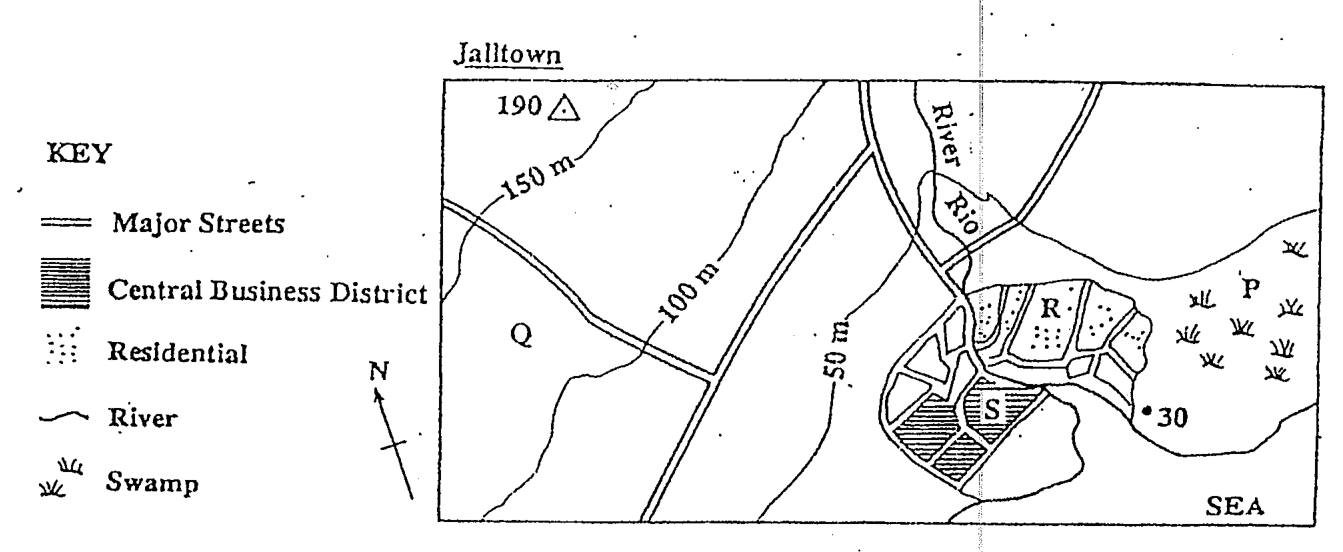
Items 13-15 refer to the following map extract at a scale of 1: 100 000.
Which of the following are the BEST rea- sons for the location of Jalltown? I. It is on flat land. II. It has a supply of fresh water. III. It is near to the swamp. IV. It is on the sea coast.
I, II and III only
I, II and IV only
II, III and IV only
I, II, III and IV
A person looking for a house to buy is BEST advised to search in area
P
Q
R
S
What is the general direction of flow of the river shown above?
North to south
South to north
East to west
West to east
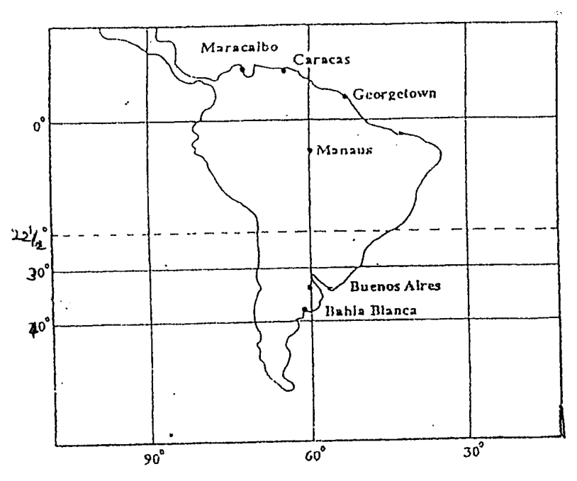
Items 16-18 refer to the following map.
Bahia Blanca is located at
33°S 61°W
35°S 60°W
36°S 60°W
38°S 61°W
Which town is located at approximately 10°N 67°W?
Manaus
Caracas
Maracaibo
Georgetown
What is the time in St Petersburg, Russia (30° E) when it is 7.00 p.m. on Monday in Philadelphia, USA (75° W)?
12.00 noon Monday
3.00 a.m. Tuesday
3.00 p.m. Monday
2.00 a.m. Tuesday
In what section of a river's course can gorges be found?
Upper
Middle
Old Age
Late
Which of the following is NOT a true statement about waves?
They are caused by wind blowing over the surface of the water.
On nearing the beach the speed of waves slackens and the tops are thrown forward.
The body of water forming the waves increases rapidly as it approaches the coast.
The stronger the wind and the greater the fetch, the more powerful the waves are.
Fold mountains form at plate boundaries that are?
Coming together
Sliding past
Pushing together
Rifting
Which of the following is not a limestone feature?
Stalactites
Swallow hole
Pillar
Laccolith
At a divergent plate boundary, the crustal plates
move towards each other
move apart from each other
slide alongside each other
sink one beneath the other
The raised portions of the earth produced by folding are known as
graben
grykes
anticlines
geosynclines
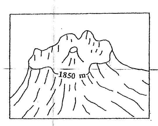
The diagram above represents a
caldera
shield volcano's cone
lava plateau
volcanic plug
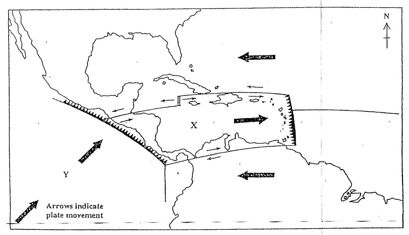
The plate labelled Y is known as the
American Plate
Caribbean Plate
Cocos Plate
Pacific Plate
Which of the above describe(s) the northern boundary of Plate X?
I only
I and III only
II and III only
1, II and III only
The eastern boundary of the Plate X is characterised by which of the above?
I only
I and II only
II and III only
1, II and III only
A volcanic spine develops because
the explosion is violent
ash and cinder are ejected
a caldera is present
the lava is viscous
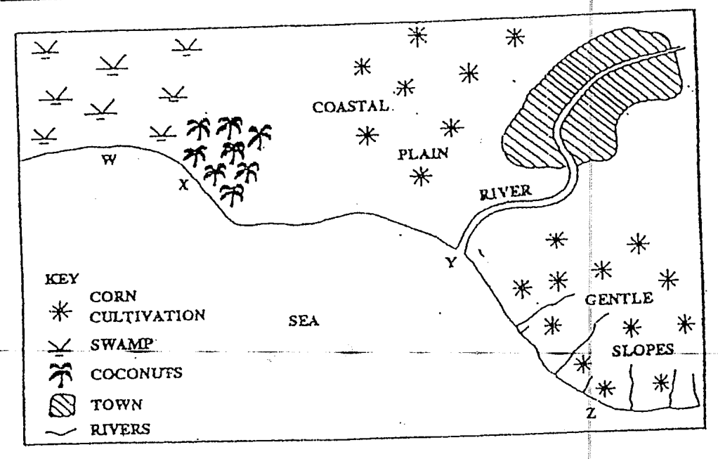
Items 30-32 are based on the sketch map below.
Water pollution is MOST likely to present a problem at
W
X
Y
Z
Which of the following factors is MOST likely to lead to a high level of water pollution along the coast shown above?
The lack of tidal currents
The dumping of waste in the river
The flatness of the land
The growing of corn on the slopes
Which of the following will control water pollution along the coast shown in the map above?
I and II only
I and III only
I, II and IV only
I, III and IV only
Which of the following practices may help to eliminate problems of pollution created by household waste?
Dumping along water courses
Burial and covering with soil
Piling up in secluded spots
Depositing in the sea
The weather system which is MOST likely to affect rainfall distribution in the Southern Caribbean is
an easterly wave
a cold front
an anticyclone
the ITCZ
Hot, wet equatorial climates are located
0°-10° N and S
10°-30° N and S
15°-30° N and S
30°-40° N and S
Which of the following BEST explain why the amount of solar energy received at the equator is greater than at the poles?
I. The equator is nearest to the sun. II. The sun's rays have to pass through a thicker layer of atmosphere at the poles. III. The sun's rays at the equator are usually direct, while at the poles they are usually slanting.
I and II only
I and III only
II and III only
I, II and III
Which of the following is not a 'push' migration factor?
Fewer and lower paying jobs
Poor healthcare
More services available
Less educational opportunities
Recent hurricanes in the Caribbean have caused fewer deaths because
the majority of the population goes to storm shelters
many have occurred during the day
families no longer live in unsafe areas
there have been improved fore- casts of hurricane tracks
Which of the following climatic types is characterised by all of the features described above?
Equatorial
Cool Temperature Interior
Tropical Marine
Tropical Continental
Which of the following determines the presence of inorganic material in a soil?
Vegetation
Parent naterial
Climate
Relief
Which of the following BEST explains why some trees in the Caribbean lose all their leaves in one season of the year?
To protect them from leaf-eating insects
To protect them from excessive moisture loss
To protect them from low temperatures
To protect them from strong winds
Which combination best describes peasant farming?
1, II and III
II, III
1, II and IV
All of the above
Which of the following BEST describes the dominant trees of equatorial regions?
Short trees with long roots
Deciduous trees with thick trunks
Tall trees with buttress roots
Evergreen trees with slender leaves
Which of the following are ways by which natural vegetation adapts to climatic conditions?
I. Development of water-storage organs II. Shedding of leaves during the dry season III. Development of long roots IV. Development of special types of leaves
I and II only
III and IV only
I, II and III only
I, II, III and IV
Which of the following is true of lines of latitude?
They meet at the north and south poles
They are all great circles
They run from east to west
They can be used to calculate time
Which of the following BEST explain why peasant farmers in the Caribbean grow a variety of crops?
I. To reduce losses caused by pests and diseases II. To maximise the use of small areas of land III. To ensure steady income all year round IV. To produce for the export market
I and II only
I, II and III only
II, III and IV only
I, II, III and IV
Which of the following has NOT had adverse effects on agricultural development in the Caribbean?
Lack of foreign markets
Hurricanes and drought
Soil erosion and infertility
Plant pests and diseases
Which of the following statements is true of subsistence farming?
Individual farms are quite small.
Yields per farmer are generally high.
Large amounts of fertilisers are used on the farm.
Crop cultivation is not as important as animal rearing.
Which of the following are methods used by Caribbean governments to improve farming in the region?
I. Providing more land to small farmers for food production II. Providing loans for the purchase of fertilisers and machinery III. Encouraging food processing to supply the local and regional markets IV. Exposing the farmers to improved methods of farming
I and II only
II, III and IV only
III and IV only
I, II, III and IV
Which of the following resources can be considered non-renewable?
Off-shore fisheries
Water
Bauxite
Mahogany trees
Which of the following is LEAST important in the location of a fishing industry?
Adequate storage facilities
A large labour force
Adequate marketing facilities
Nearness to the sea
Which of the following is the MAIN reason why flour mills in the Caribbean are situated on coastal locations?
Nearness to facilities for unloading raw materials
Nearness to the waste disposal facilities
Availability of cheap power supply
Availability of cheap labour
Which of the following BEST explains why the most common manufacturing industry in the Caribbean is food processing?
It is cheaper to produce than to import foods.
Agricultural raw materials are readily available.
A variety of mineral reserves is absent.
It does not require the use of imported fuel.
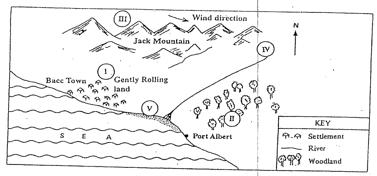
Which of the following would be the BEST area to locate a new factory in order to minimize the effects of air pollution?
I
II
III
IV
Which area is MOST LIKELY to be developed as a tourist resort?
I
II
IV
V
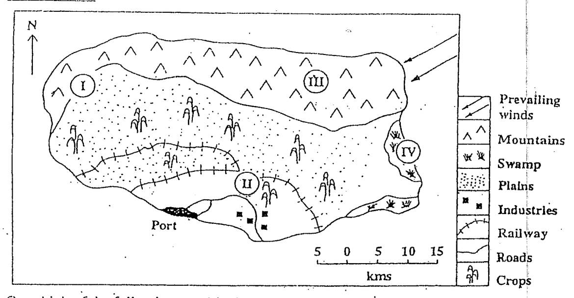
Items 56 - 57 refer to the map below.
On which of the following would a large settlement MOST likely be developed?
I
II
III
IV
What type of settlement pattern would MOST likely occur in the area shaded AAA in the map above?
Linear
Radial
Nucleated
Dispersed
The growth of population in urban areas is usually referred to as
urbanization
urban sprawl
sub-urbanization
population growth
Rapid urbanization in Caribbean countries USUALLY results in
increased employment in the cities
decreased foreign exchange earnings
improvement in the standard of living
housing shortages in the cities
Which is an example of air pollution?
Mercury
Smog
Oil spill
Fertilizer runoff