Free CXC Geography Paper 1 May/June 2010 past paper from 2010. Includes a worked answer key. Open the PDF, take a timed test, and study with AI on Caribbean AI.
Answer keys are free on Caribbean AI. View the answers to every past-paper question at no cost - no payment needed - with step-by-step worked solutions and instant AI marking available on Premium.
CSEC Geography Paper 1 May/June 2010 - Free CXC Past Paper with Answers
Free CXC Geography Paper 1 May/June 2010 past paper from 2010. Includes a worked answer key. Open the PDF, take a timed test, and study with AI on Caribbean AI.
Opening the interactive papers…
Every question from this paper as text. See the answers and worked solutions. Questions are the property of the Caribbean Examinations Council; Caribbean AI is not affiliated with CXC.
The diagram above shows a cross-section of a river valley. Which of the following processes is MOST responsible for the formation of the valley shown?
Erosion
Deposition
Weathering
Mass movement
The diagram above shows a cross-section of a river valley. Which of the following processes is MOST responsible for the formation of the valley shown?
Erosion
Deposition
Weathering
Mass movement
The diagram above shows a cross-section of a river valley. Which of the following processes is MOST responsible for the formation of the valley shown?
Erosion
Deposition
Weathering
Mass movement
The diagram above shows a cross-section of a river valley. Which of the following processes is MOST responsible for the formation of the valley shown?
Erosion
Deposition
Weathering
Mass movement
The diagram above shows a cross-section of a river valley. Which of the following processes is MOST responsible for the formation of the valley shown?
Erosion
Deposition
Weathering
Mass movement
The diagram above shows a cross-section of a river valley. Which of the following processes is MOST responsible for the formation of the valley shown?
Erosion
Deposition
Weathering
Mass movement
The diagram above shows a cross-section of a river valley. Which of the following processes is MOST responsible for the formation of the valley shown?
Erosion
Deposition
Weathering
Mass movement
The diagram above shows a cross-section of a river valley. Which of the following processes is MOST responsible for the formation of the valley shown?
Erosion
Deposition
Weathering
Mass movement
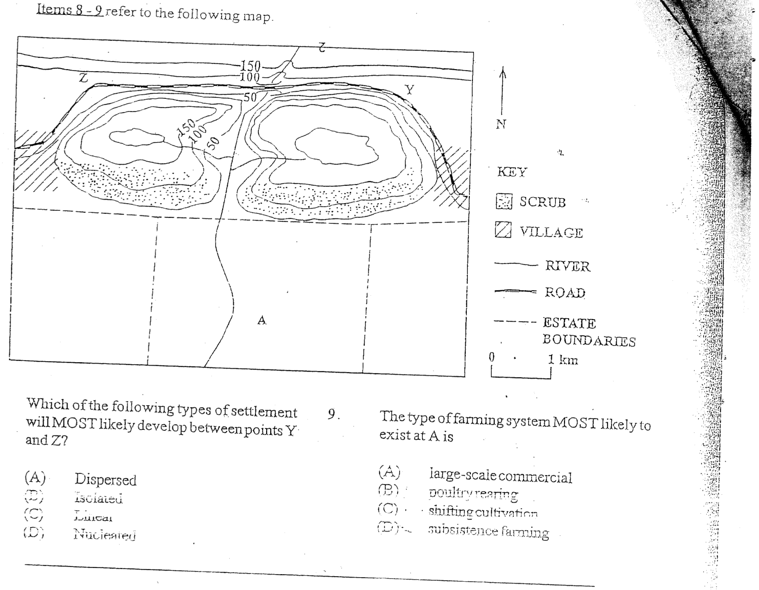
The type of farming system MOST likely to exist at A is
large-scale commercial
poultry rearing
shifting cultivation
subsistence farming
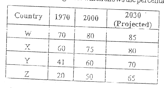
Items 10-11 refer to the following table which shows the percentage of total population in urban areas.
In which country is urbanisation occurring the FASTEST?
W
X
Y
Z
Which of the following representations is MOST suitable for the information in the table above?
Bar graph
Dot map
Isoline
Pie chart
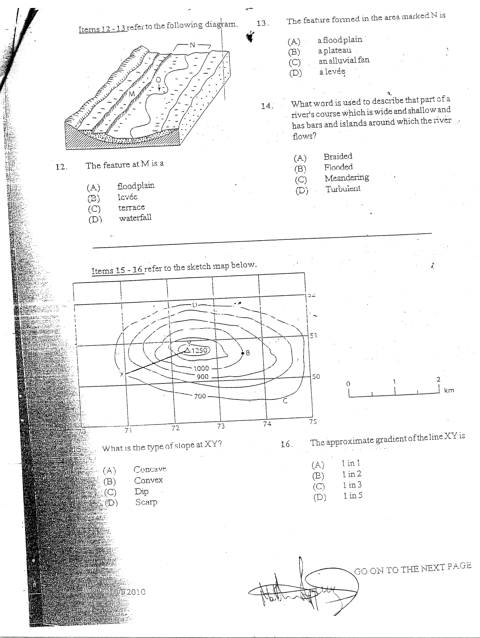
Items 12-13 refer to the following diagram.
The feature at M is a
floodplain
levée
terrace
waterfall
The feature formed in the area marked N is
a floodplain
a plateau
an alluvial fan
a levée
What word is used to describe that part of a river's course which is wide and shallow and has bars and islands around which the river flows?
Braided
Flooded
Meandering
Turbulent
Items 15 - 16 refer to the sketch map below.
What is the type of slope at XY?
Concave
Convex
Dip
Scarp
The approximate gradient of the line XY is
1 in 1
1 in 2
1 in 3
1 in 5
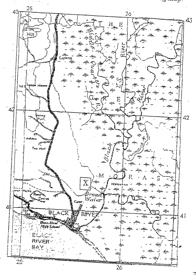
Items 17-18 refer to the following map.
On the map extract above, the feature labelled X at (257412) is a
confluence
deferred junction
distributary
river capture
The general direction of flow of the Black River is
NNE
SSW
NE
SE
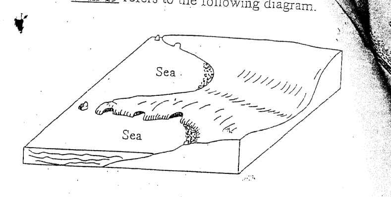
Item 19 refers to the following diagram.
Which of the following features is NOT shown on the diagram?
Bay-head beach
Cliff
Headland
Wave-cut platform
It is true that lines of latitude
meet at the poles
are NOT all of the same length
are East or West of Greenwich
have angles that increase towards the equator
A correct relationship between longitude and time is that the time changes by
4 minutes for 1°
1 minute for 4°
1 hour for 20°
24 hours for 180°
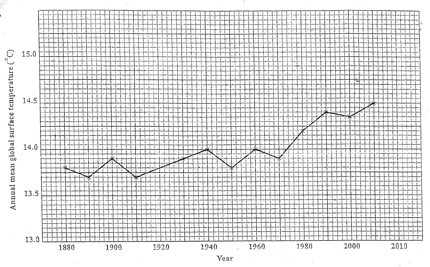
Items 22-24 refer to the graph below showing long-term changes in global temperatures.
What degree of change in global temperatures was recorded between 1910 and 1940?
0.2
0.3
0.4
0.5
The LARGEST change in the annual mean global temperatures occurred over the period
1890-1910
1920-1940
1950-1970
1970-1990
The general trend of the annual mean global temperatures shown in the graph above is
a consistency in temperatures
a decrease in temperatures
an increase in temperatures
a great fluctuation in temperatures
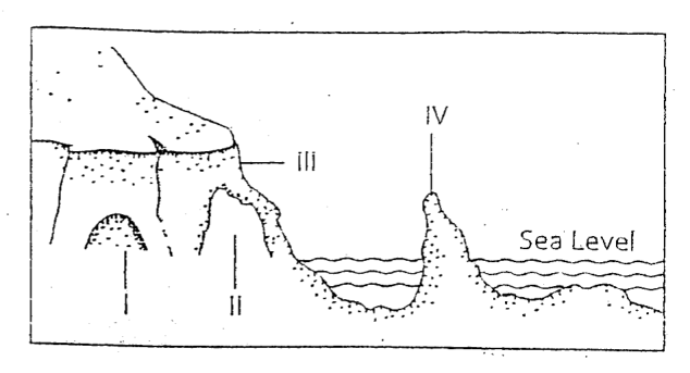
Item 25 refers to the following diagram.
The CORRECT order of the features labelled by I, II, III, IV is
arch, cave, stack, cliff
cave, arch, cliff, stack
cliff, cave, stack, arch
stack, cliff, arch, cave
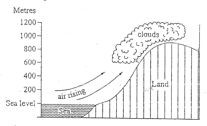
At what height, in metres, above sea-level does condensation begin?
200
400
600
1200
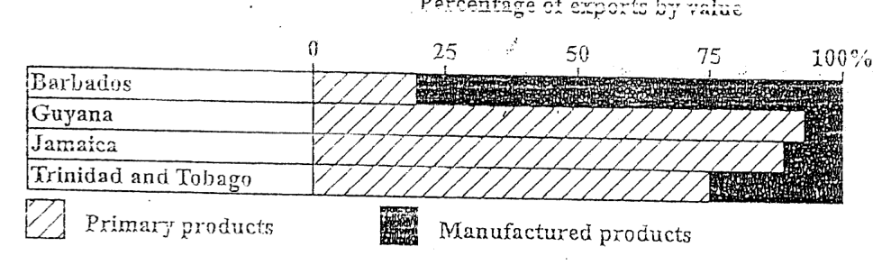
For which of the following territories was the value of manufactured products exported GREATER than 75% of the total exports?
Barbados
Guyana
Jamaica
Trinidad and Tobago
Which of the following territories showed the GREATEST difference in value between primary and manufactured products?
Barbados
Guyana
Jamaica
Trinidad and Tobago
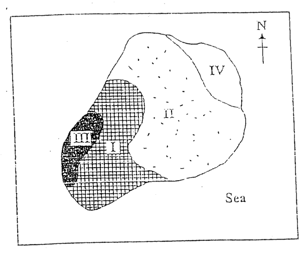
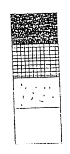
Items 29-30 refer to the diagram below.
The mapping technique above is used to show population
movement
change
density
distribution
Which part of the island (I, II, III or IV) has the SMALLEST population?
I
II
III
IV
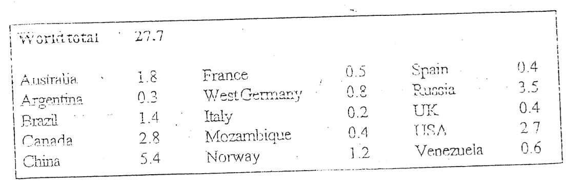
Items 31-33 refer to the data below regarding world production of aluminium (million tonnes) in selected countries for 2002
Which country produced just over one-eighth of the aluminium in the world in 2003?
Russia
Canada
Argentina
USA
The number of tonnes of aluminium produced by Argentina is
3 000
30 000
300 000
5 000 000
Plate subduction occurs at
convergent plate boundaries
divergent plate boundaries
mid-oceanic ridges
transform plate boundaries
Fold mountains form where plates of the earth's crust move
away from each other
parallel to each other
towards each other
up and down
Which of the following features of rocks has the LEAST influence on their rate of chemical weathering?
Size
Porosity
Temperature
Mineral composition
Which of the following is NOT a true statement about waves?
On nearing the shore their tops are thrown forward.
The stronger the wind and the greater the fetch, the more powerful they are.
They are caused by wind blowing over the surface of the water..
In the open sea there is great forward movement of water.
A river gorge MAY be formed as a result of the
deposition of material
erosion of the concave bank of a river
increasing volume of the river
upstream retreat of a waterfall
It is NOT true that coral reefs
grow best in shallow coastal water
secrete calcium carbonate
are found near the mouths of large rivers
require warm, sunlit waters
Which of the following are elements of weather? I. Altitude II. Latitude III. Cloud cover IV. Temperature
I and II only
I and III only
II and IV only
III and IV only
"The temperature suddenly drops and wind speed increases; the sky gradually becomes overcast and there is a slight drizzle." What type of weather system is described above?
ITCZ
Cold front
Easterly wave
Hurricane
Which combination of the following factors would MOST likely result in flooding?
I. Soil conservation methods are in use. II. Leaching is widespread. III. There is deforestation of steep slopes. IV. There is excessive dumping of garbage in rivers.
I and II only
III and IV only
II, III and IV only
I, II, III and IV
A traveller made the following observations:
"It was hot and rained heavily every day; the trees grew very tall and there was little undergrowth."
Which of the following vegetation types was the traveller describing?
Equatorial Forest
Mangrove Forest
Tropical Montane Forest
Tropical Savannah
Which of the following explains the population growth in urban centres in the Caribbean?
High birth and death rates
An ageing population
An increase in emigration
Migration from rural areas
Which of the following is associated with urbanisation in the Caribbean?
Shortage of labour
Poor shopping facilities
Poor housing conditions
Absence of paved roads
Which of the following is classified as a tertiary industry?
Fishing
Food processing
Oil refining
Tourism
Which of the following measures can governments use to influence the location of industries?
I. Introduction of zoning regulations II. Provision of the necessary infrastructure III. Offer of training programmes to employees IV. Provision of tax incentives
I, II and III only
I, II and IV only
I, III and IV only
I, II, III and IV
Which of the following may NOT result in river flooding?
Deforestation
Dredging of the river
Excessive deposition in the river bed
Heavy prolonged rainfall
Vegetation contributes to the development of soils by
producing humus
providing inorganic minerals
providing the parent material
increasing the depth of the soil
Which of the following are challenges to peasant farmers in the Caribbean?
I. Lack of capital II. Lack of crop variety III. Soil erosion
I and II only
I and III only
II and III only
I, II and III
Which of the following would NOT be classified as arable farming?
Cattle ranching
Fruit farming
Market gardening
Sugarcane growing
Which of the following is the MOST important consideration in the location of primary industries?
Labour
Power
Transportation
Raw materials
The total output from peasant farms is often low because
farmers grow mainly food crops
holdings are very small
plots are located in remote areas
only one crop is grown
Which of the following are methods used by Caribbean governments to improve farming in the region?
I. Providing more land to small farmers for food production II. Providing loans for the purchase of fertilisers and machinery III. Encouraging food processing to supply the local and regional markets IV. Exposing the farmers to improved methods of farming
I and II only
III and IV only
II, III and IV only
I, II, III and IV
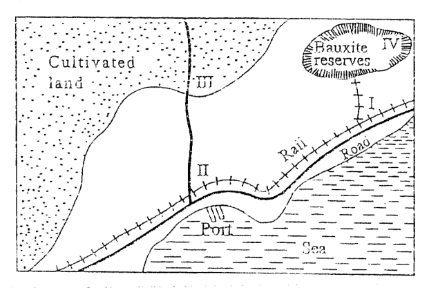
Item 54 refers to the following diagram.
Based on the diagram above, the BEST location for an urban centre is at
I
II
III
IV
Which of the following is a form of air pollution?
Mercury poisoning
Oilspill
Raw sewage
Smog
Which of the following poses the MOST serious threat to the rivers of the Caribbean?
Illegal dumping of waste
Deforestation and erosion
Tourist activities
Improper fishing practices
Which of the following can pollute the underground water supply? I. Chemical fertilisers II. Mulch III. Pesticides
I and II only
I and III only
II and III only
I, II and III
Which of the following may cause damage to coral reefs in the Caribbean?
Muddy water
Oxygen
Shallow water
Sunlight
Which of the following may harm the marine environment of the Caribbean? I. Zoning of marine activities II. Harvesting of coral formations for souvenirs III. Discharging sewage and industrial waste along the shore
I and II only
I and III only
II and III only
I, II and III
"Algae, nourished by waters enriched with nutrients, grow in abundance over the corals causing them to die."
The situation described above can come about through
dredging and mining
dynamiting fish
oil pollution
sewage discharge