Free CXC Geography Paper 1 May/June 2015 past paper from 2015. Includes a worked answer key. Open the PDF, take a timed test, and study with AI on Caribbean AI.
Answer keys are free on Caribbean AI. View the answers to every past-paper question at no cost - no payment needed - with step-by-step worked solutions and instant AI marking available on Premium.
CSEC Geography Paper 1 May/June 2015 - Free CXC Past Paper with Answers
Free CXC Geography Paper 1 May/June 2015 past paper from 2015. Includes a worked answer key. Open the PDF, take a timed test, and study with AI on Caribbean AI.
Opening the interactive papers…
Every question from this paper as text. See the answers and worked solutions. Questions are the property of the Caribbean Examinations Council; Caribbean AI is not affiliated with CXC.
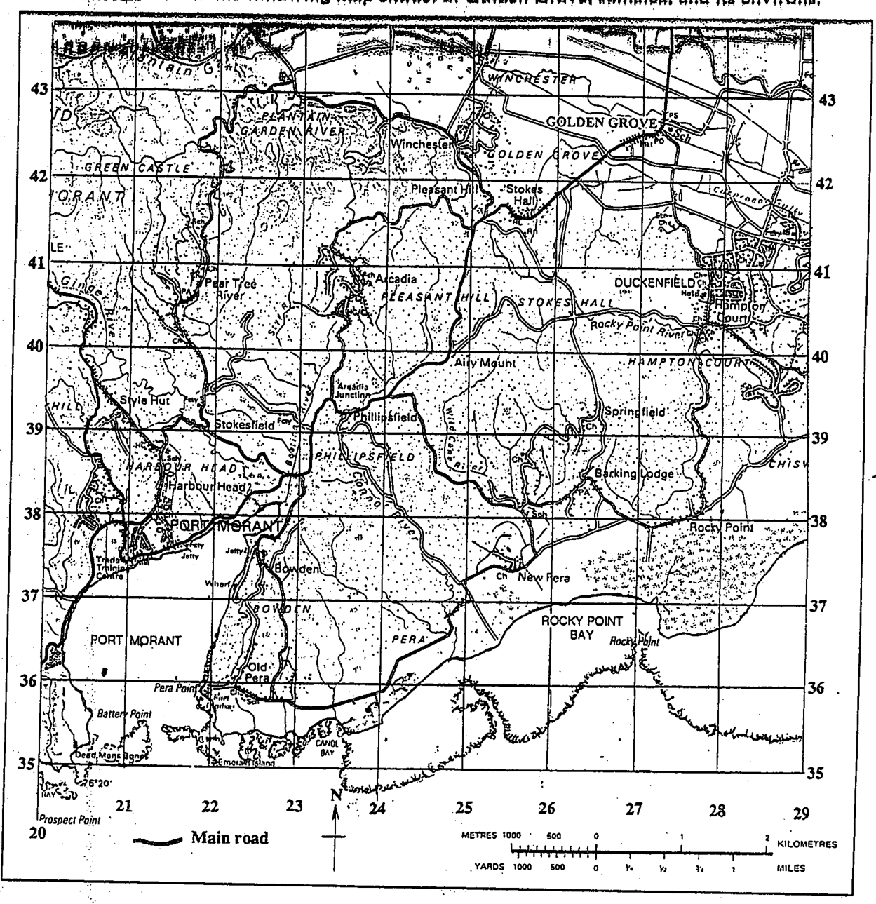
What is the grid reference of the school (Sch) at Golden Grove?
273426
287434
426273
434287
The general direction of Port Morant from Golden Grove is
northeast
northwest
southwest
southeast
The bearing of the main road junction at Golden Grove from the main road junction at Arcadia Junction (near Easting 24) is APPROXIMATELY
045°
132°
228°
312°
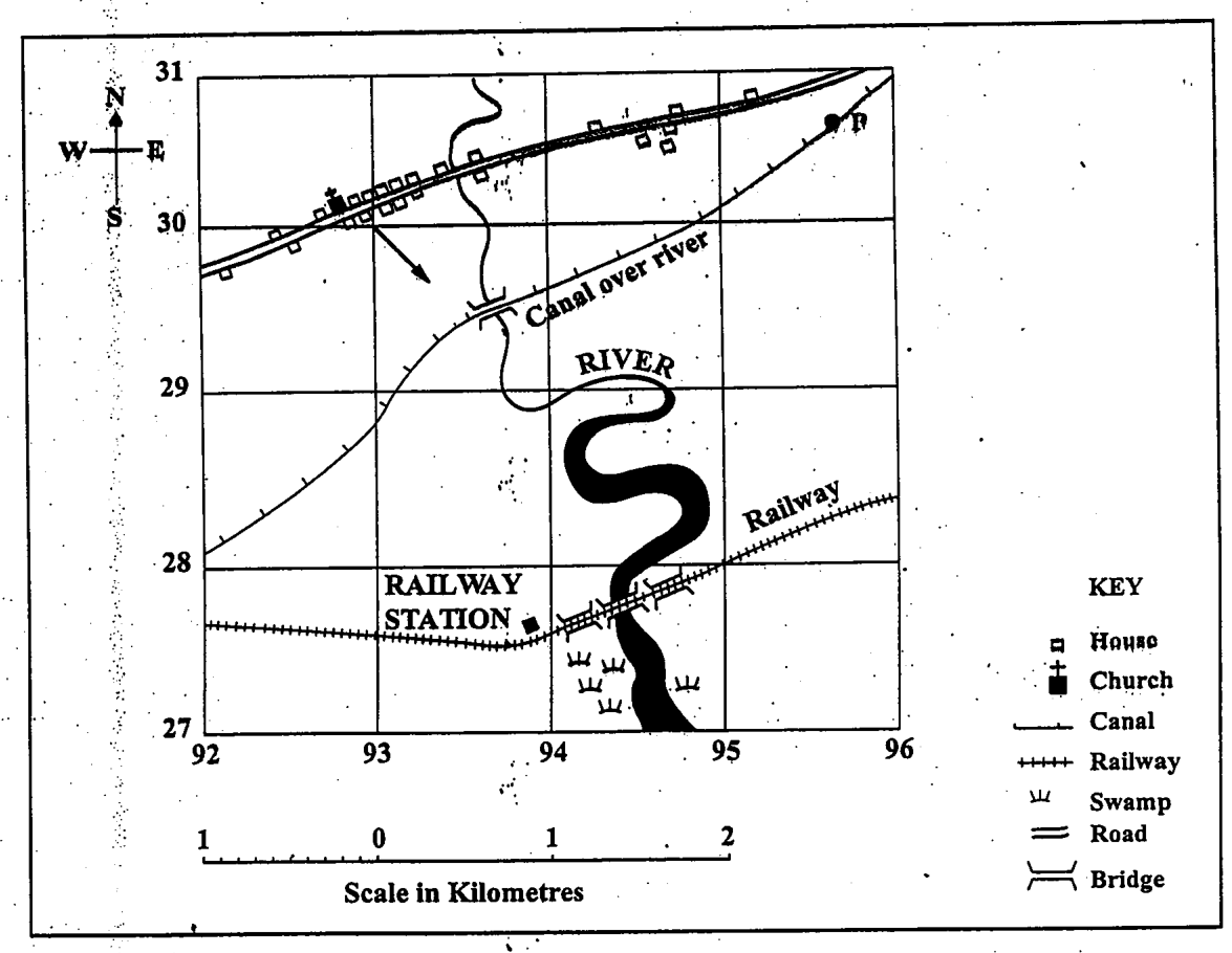
Items 4-5 refer to the following map.
What is the form of the settlement in which the church is located?
Isolated
Linear
Dispersed
Nucleated
The feature passing through P is a
road
river
canal
railway
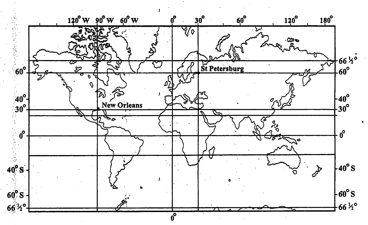
Items 6-7 refer to the following world map.
What is the location of St Petersburg?
30°N 90°W
30°N 60°W
60°N 30°W
60°N 30°E
What time is it in New Orleans when it is 10:00 p.m. on Monday in St Petersburg?
2:00 a.m. Sunday
2:00 p.m. Sunday
2:00 a.m. Monday
2:00 p.m. Monday
The direction of the prime meridian from New Orleans is
east
west
north
south
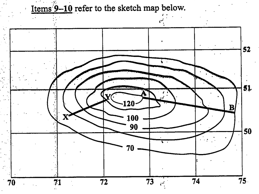
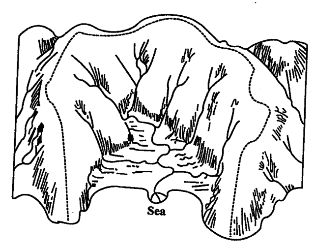
Items 9-10 refer to the sketch map below. <image>
What is the type of slope at XY?
Dip
Scarp
Convex
Concave
The approximate gradient of the line AB is
1 in 10
1 in 20
1 in 40
1 in 50
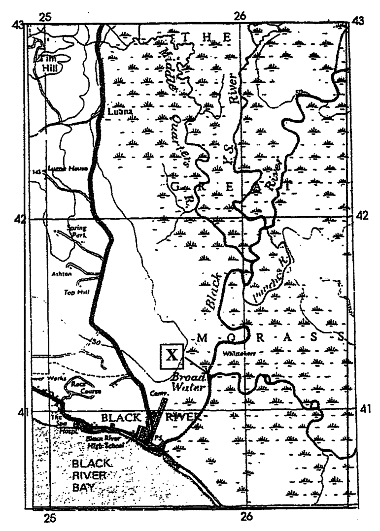
Items 11-12 refer to the following map extract of the Black River area, Jamaica.
On the map extract, the feature labelled X (at 257412) is a
confluence
distributary
river capture
deferred junction
The general direction of flow of the Black River is
SE
NE
NNE
SSW
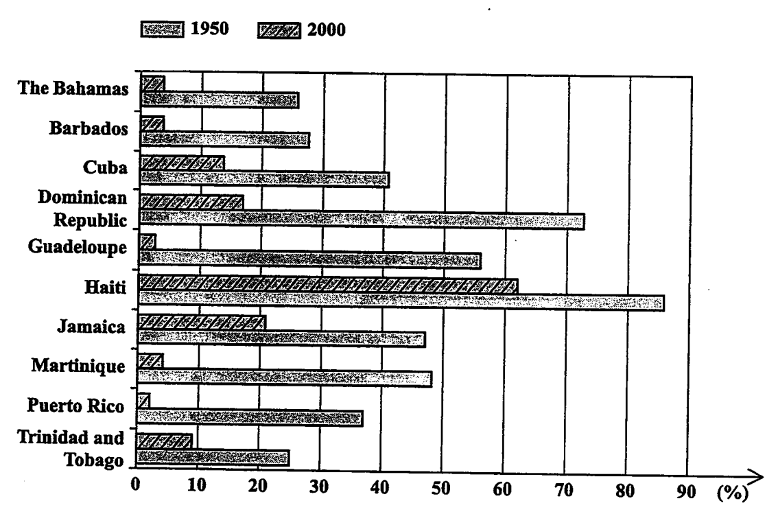
Items 13-15 refer to the following graph which shows the percentage of total population employed in agriculture in 1950 and 2000 in some Caribbean territories.
Which country had the LARGEST percentage decline in people employed in agriculture?
Haiti
Martinique
Dominican Republic
Trinidad and Tobago
In 2000, the country with the LOWEST percentage of people employed in agriculture was
Barbados
Martinique
Puerto Rico
Guadeloupe
In which countries did employment in agriculture decline by more than 40 per cent of the total population over the period?
Haiti, Guadeloupe, Puerto Rico
Dominican Republic, Guadeloupe, Haiti
Dominican Republic, Jamaica, Martinique
Dominican Republic, Guadeloupe, Martinique
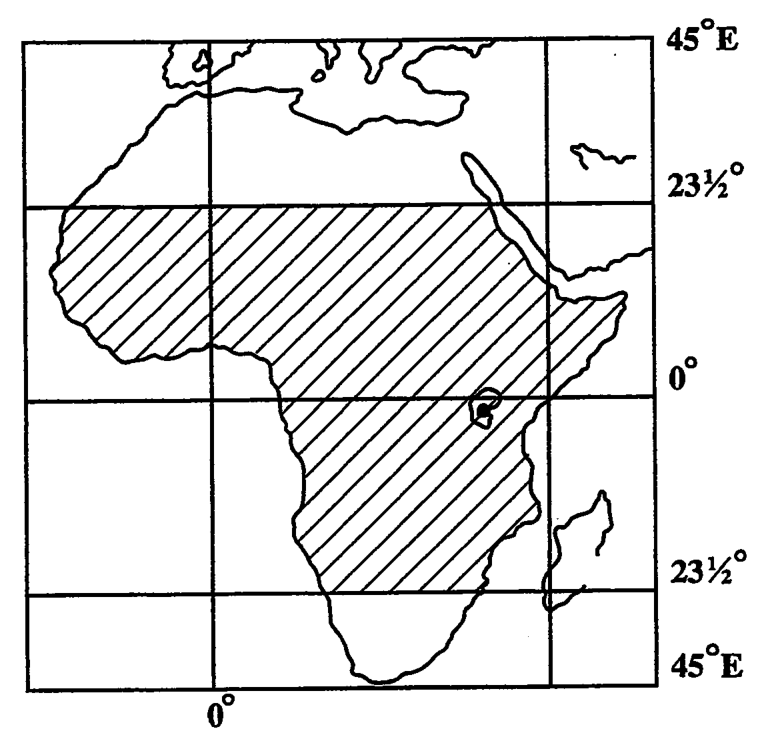
Item 16 refers to the following map of a continent.
The shaded area on the map is BEST described as the
Tropics
Arctic Zone
Mediterranean
Temperate Zone
Which of the following statements about lines of latitude is true?
They meet at the poles.
They are all great circles.
They represent angular distance from the prime meridian.
They represent the angular distance north and south of the equator.
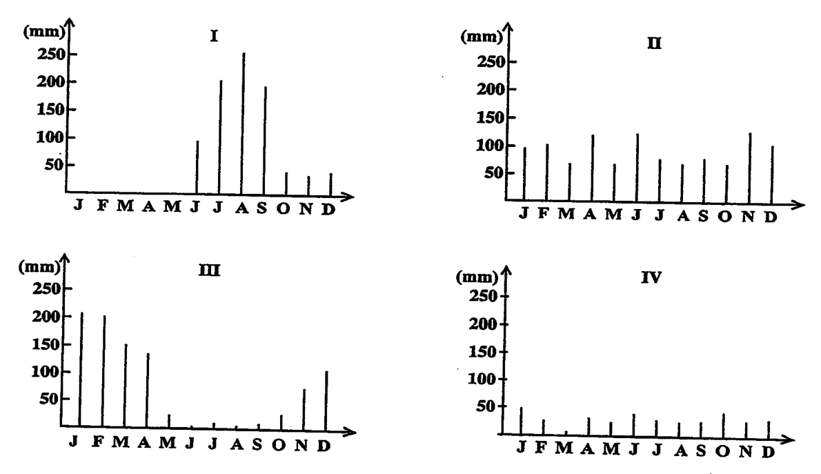
Items 18-19 refer to the following graphs which show rainfall conditions, I, II, III and IV.
Under which of the conditions would the flow of a river vary MOST from season to season?
I and II only
I and III only
II and III only
II and IV only
Under which of the conditions is there the GREATEST variation in rainfall?
I only
II only
III only
IV only
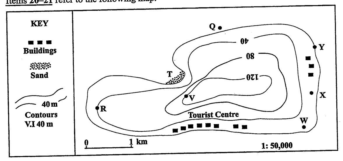
Items 20-21 refer to the following map. KEY Buildings Sand 40 m Contours V.I 40 m Scale: 2 cm = 1 km
The features found at T on the map are
a bay and beach
a headland and bay
a beach and headland
cliffs and coral reefs
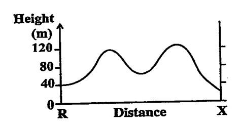
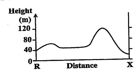
A contour sketch from Point R to Point X would look like
Height (m) 120 80- 40- 0 R Distance X
Height (m) 120- 80- 40- 0 R Distance X
Height (m) 120 80 40 0 R Distance X
Height (m) 120- 80- 40- 0 R Distance X
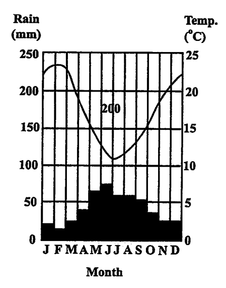
Items 22-23 refer to the following rainfall and temperature graph.
The annual range of temperature is APPROXIMATELY
Which of the following statements is true?
The hottest months of the year are also the driest.
The hottest months of the year are also the wettest.
There is little variation in rainfall throughout the year.
There is little variation in temperature throughout the year.
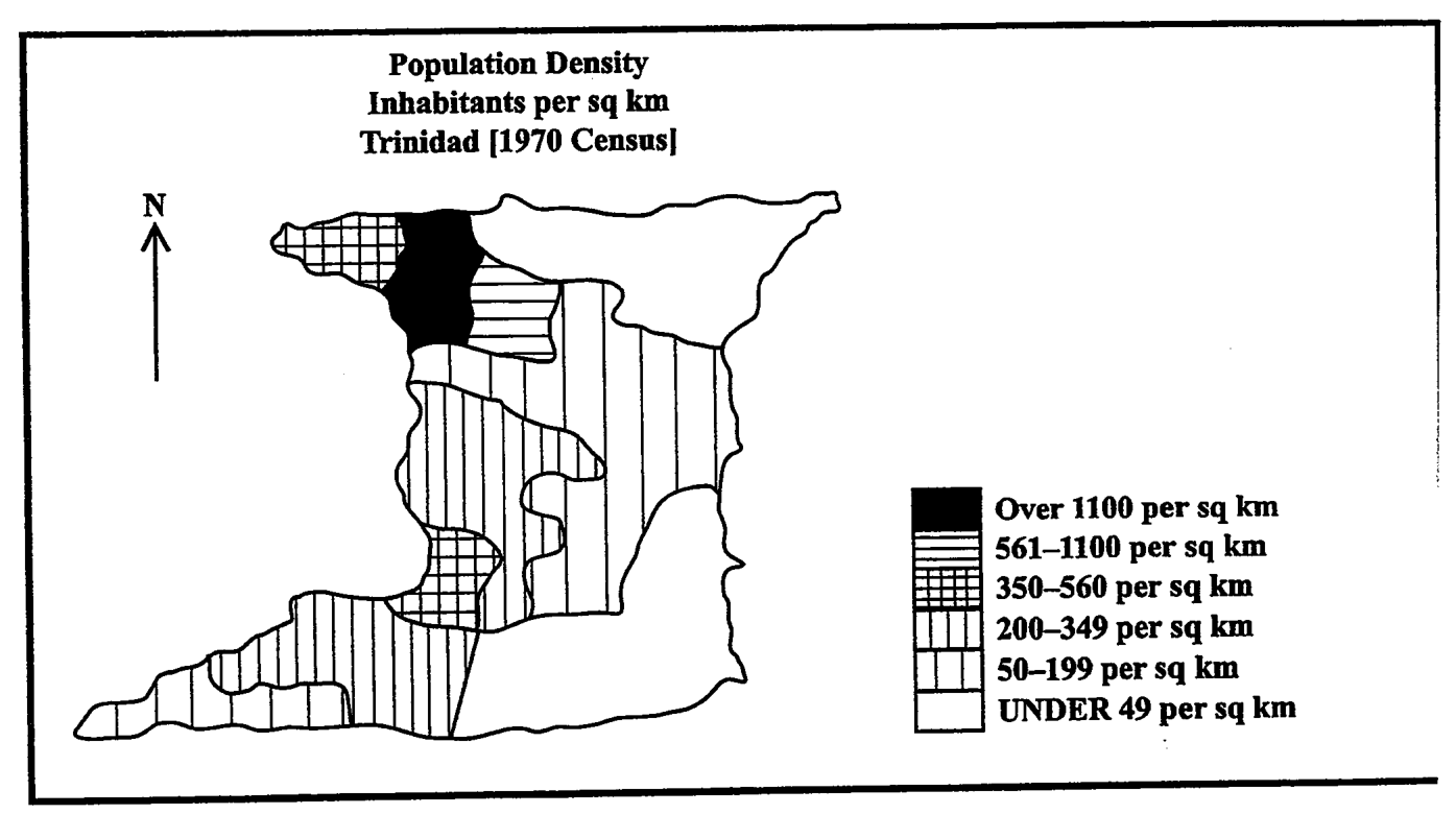
Item 24 refers to the following population density map of Trinidad.
Which of the following statements is true according to the population density map of Trinidad?
The west has the lowest population.
The southwest is sparsely populated.
The centre has the highest population.
The northwest is densely populated.
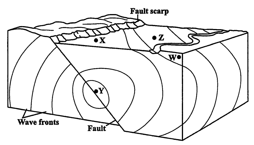
Which of the points in the diagram represents the focus?
W
X
Y
Z
Which of the following statements is NOT true of ALL volcanoes?
Their eruptions are violent.
They occur in areas of crustal weakness.
Their cones are made of ejected material.
Various gases are emitted during eruption.
When magma emerges on the surface, it may lead to the formation of
sills
dykes
laccoliths
lava flows
Potholes will tend to form on the bed of a river if the river has a
low volume and flows over a steep gradient
high volume and flows over a steep gradient
low volume and flows over a gentle gradient
high volume and flows over a gentle gradient
As one climbs a mountain, the surrounding temperature
decreases
increases
fluctuates
remains constant
How does vegetation contribute to the development of soils?
It provides the parent material.
Roots increase the depth of soil.
It decomposes to form humus.
It decomposes to produce inorganic matter.
The slow downhill movement of debris and soil under the influence of gravity may BEST be described as
a landslide
soil creep
soil erosion
mass wasting
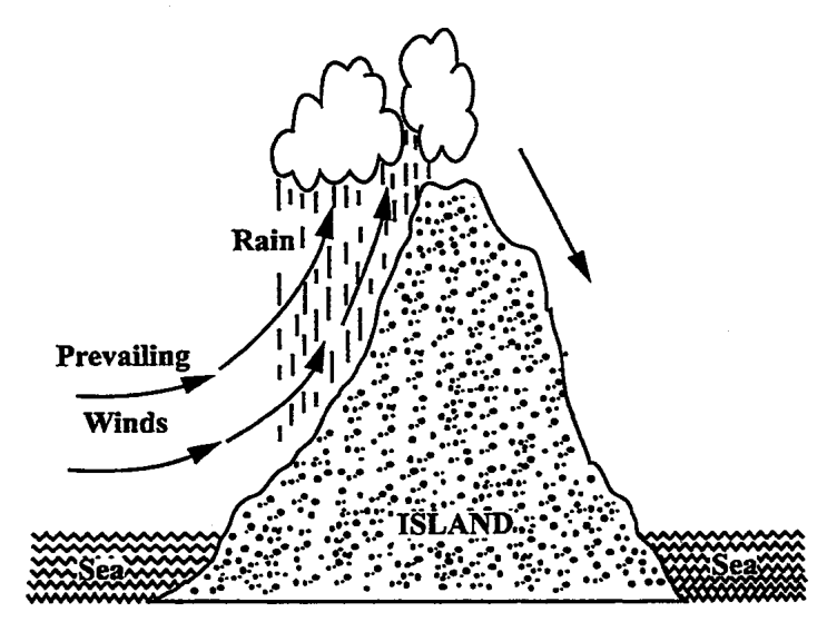
Item 32 refers to the following diagram.
Which of the following weather conditions is NOT shown in the diagram above?
Rain shadow on the leeward side
Frontal rainfall on the mountain top
Relief rainfall on windward slopes
Descending dry winds on the leeward side
The MAIN difference between weathering and erosion relates to the
removal of materials
temperature of the materials
moisture content of the rocks
slope of the land bearing the rocks
What is the CORRECT order of the stages in the development of a hurricane?
Tropical disturbance, storm, depression, hurricane
Tropical depression, disturbance, storm, hurricane
Tropical storm, depression, disturbance, hurricane
Tropical disturbance, depression, storm, hurricane
Fold mountains form where crustal plates move
up and down
towards each other
parallel to each other
away from each other
Which of the following phrases defines exfoliation?
Peeling off of the outer layers of rocks
Splitting of rocks into rectangular blocks
Movement of rocks due to the action of rivers
Disintegration of rocks by root penetration into crevices
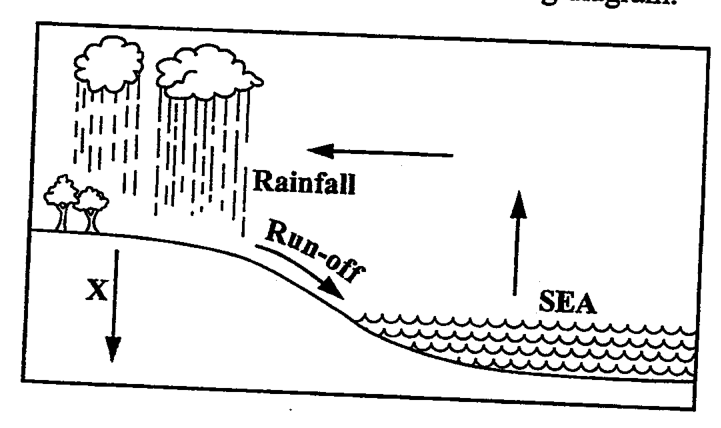
In the diagram, X represents
percolation
evaporation
transpiration
precipitation
The dotted line represents
a plateau
the hilltop
the watershed
the drainage basin
Which of the following statements may explain why some areas in Caribbean territories are sparsely settled?
I. They are hilly and forested. II. They have no mineral resources. III. Transport links are generally poor.
I and II only
I and III only
II and III only
I, II and III
Which of the following conditions is NOT likely to result from the setting up of secondary (manufacturing) industries in the Caribbean?
Increased exports
Reduced cost of living
Increased employment opportunities
Reduction in the importation of consumer goods
Rapid urbanization in Caribbean countries USUALLY results in
housing shortages in the cities
increased employment in the cities
decreased foreign exchange earnings
improvement in the standard of living
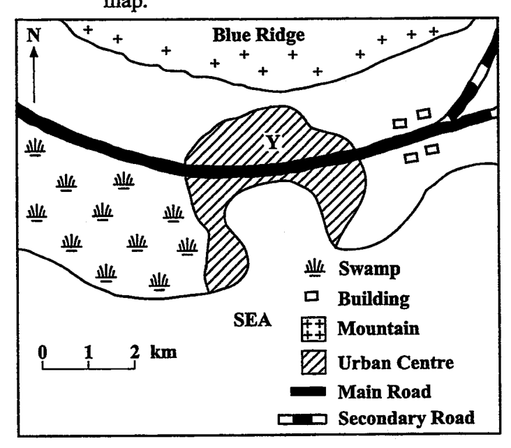
Items 42-43 refer to the following sketch map. + N + + + Blue Ridge + + 业 عياد علام علام 业 业 业业 ㅁㅁ Swamp Π Building Mountain Urban Centre Main Road Secondary Road 0 1 2 km SEA
Which of the following features BEST explain the location of the urban centre in the sketch map? I. The presence of flat land II. The nearness to the mountains ΙΙΙ. The presence of a natural harbour
I and II only
I and III only
II and III only
I, II and III
In which direction is the town MOST likely to expand?
East
West
North
South
Which of the following factors is the MOST important in the location of primary industries?
Labour
Power
Transportation
Raw materials
"Algae, nourished by waters enriched with nutrients, grow in abundance over the corals causing them to die." The situation described above can result from
oil pollution
fishing and dynamite
dredging and mining
sewage discharge
Which of the following features exert the GREATEST influence on tourism in the Caribbean?
Climates
Carnivals
Coral reefs
Tropical forests
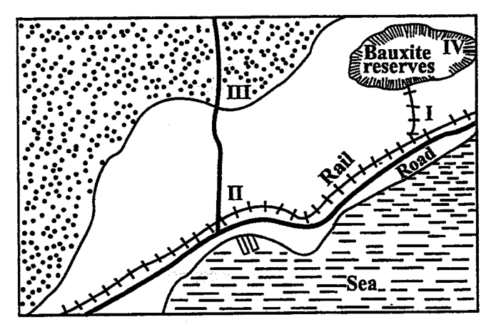
Item 47 refers to the following diagram which shows four locations labelled I, II, III and IV. Bauxite IV reserves Π Rail Road Sea
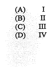
Based on the diagram, at which of the locations is an urban centre MOST likely to be found?
I
II
III
IV
Which of the following conditions is NOT a problem affecting industrial development in the Caribbean?
Size of market
Availability of capital
Size of labour force
Quantity of raw materials
Which of the following circumstances are challenges to peasant farmers in the Caribbean? I. Lack of capital II. Lack of crop variety III. Soil erosion
I and II only
I and III only
II and III only
I, II and III
The total output from peasant farms is often low because
only one crop is grown
holdings are very small
farmers grow mainly food crops
plots are located in remote areas
Which of the following practices may harm the marine environment in the Caribbean? I. Zoning of marine activities II. Harvesting of coral formations for souvenirs III. Discharging sewage and industrial waste along the shore
I and II only
I and III only
II and III only
I, II and III
Which of the following situations contributes MOST to pollution of the environment of capital cities in CARICOM countries?
Accumulation of garbage from factories
Discharge of chemicals in the sea
Discharge of fish waste in the sea
Discharge of exhaust fumes from motor vehicles
Which of the following is a form of air pollution?
Smog
Oil spill
Raw sewage
Oxygen depletion
Which of the following practices may help to eliminate problems of pollution created by organic household waste?
Depositing in the sea
Piling up in secluded spots
Burying and covering with dirt
Dumping along water courses
Harmful gases, liquids and solids which affect the earth and its inhabitants are examples of
sediments
pollutants
solid waste
contaminants
Which of the following features indicates an UNHEALTHY coral reef?
Brightly coloured coral
Large number of parrot fish
Large variety of species of coral
Extensive area of bright white coral
Items 57-58 refer to the following diagram showing a series of consequences from tropical deforestation. Tropical Deforestation Great Overland Flow X Soil Erosion
Which of the following consequences BEST represents X?
Flooding
Reduced rainfall
Decreased canopy
Reduced soil fertility
What other consequence can result from tropical deforestation?
Lumbering
Loss of flora
Increase in fauna
Increase in underground water
Flooding can be prevented by I. planting vegetation II. creating reserves for trees III. clearing vegetation on slopes
I and II only
I and III only
II and III only
I, II and III
Which of the following actions can be used to reduce the emission of greenhouse gases? I. Increased use of chlorofluorocarbons (CFCs) II. Increased use of solar power III. Reduction in the use of fossil fuels
I and II only
I and III only
II and III only
I, II and III