Free CXC Geography Paper 1 May/June 2004 past paper from 2004. Includes a worked answer key. Open the PDF, take a timed test, and study with AI on Caribbean AI.
Answer keys are free on Caribbean AI. View the answers to every past-paper question at no cost - no payment needed - with step-by-step worked solutions and instant AI marking available on Premium.
CSEC Geography Paper 1 May/June 2004 - Free CXC Past Paper with Answers
Free CXC Geography Paper 1 May/June 2004 past paper from 2004. Includes a worked answer key. Open the PDF, take a timed test, and study with AI on Caribbean AI.
Opening the interactive papers…
Every question from this paper as text. See the answers and worked solutions. Questions are the property of the Caribbean Examinations Council; Caribbean AI is not affiliated with CXC.
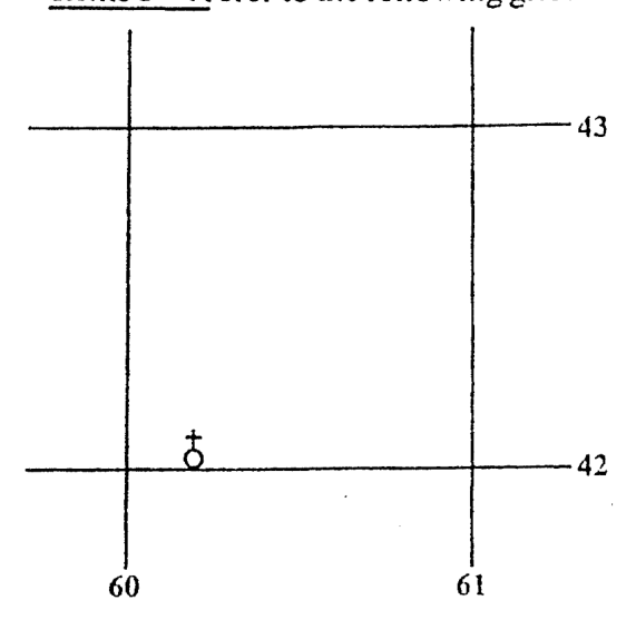
What is the six-figure grid reference for the symbol (8) shown on the grid above?
604431
602420
431604
420602
The symbol (8) in the grid above represents a
school
clock-tower
church
post office
Which of the following is NOT associated with folding?
Creation of mountain ranges such as the Alps and Himalayas
Nappes
Anticlines
Horsts block mountains
Which of the following may cause marine pollution? I. Sewage II. Oil spills III. Deforestation IV. Industrial waste
I and II only
II, III and IV only
I, II and III only
I, II, III and IV
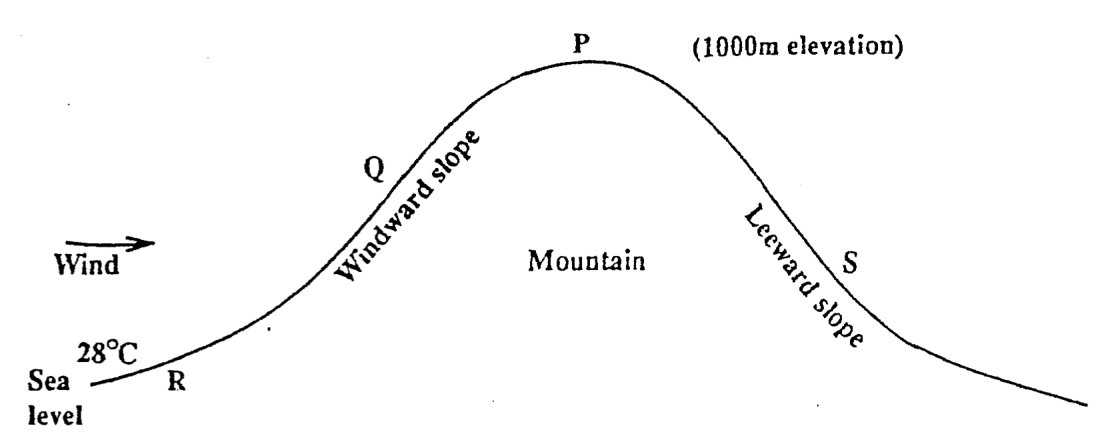
Items 7-9 refer to the diagram below.
The temperature at the top of the mountain would most likely be
26°C
22°C
32°C
30.3°C
The main factor responsible for the difference in temperature between places P and R is
altitude
latitude
cloud cover
distance from the sea
From the diagram above, which of these statements is MOST LIKELY to be true?
Place P will receive more rainfall than place S.
Place S will receive more rainfall than place Q.
Place R and P will receive the same amount of rainfall.
Place Q will receive less rainfall than place R.
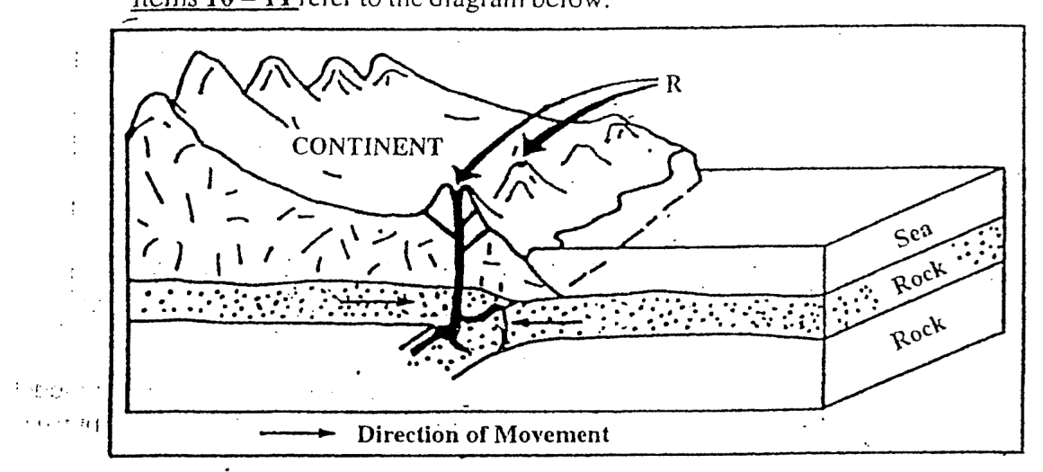
Items 10-11 refer to the diagram below.
The plate margin shown is
conservative
creative
convergent
convectional
The features shown at R are
volcanoes
fold mountains
block mountains
a volcanic island arc
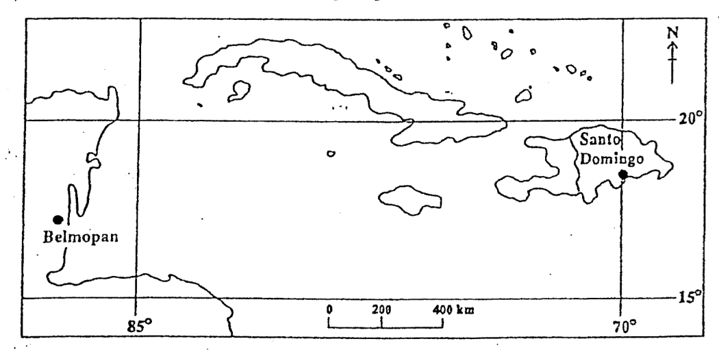
Items 12-13 refer to the following map of the Caribbean.
Belmopan is located nearest to
17° South, 88° West
17° North, 88° West
18° South, 85° West
18° North, 88° East
If the time at Belmopan is 3.00 p.m., what is the time at Santo Domingo?
4.00 p.m.
2.00 p.m.
4.00 a.m.
2.00 a.m.
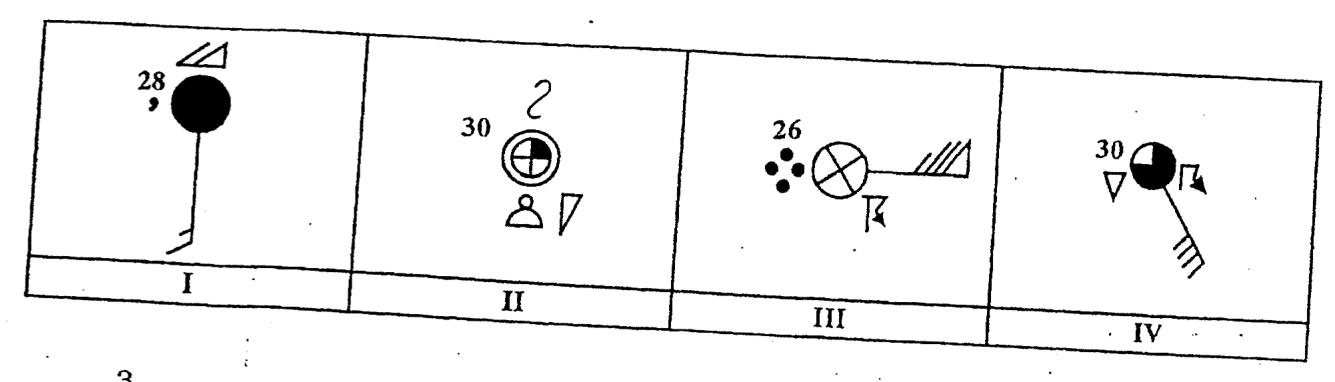
Items 14-15 refer to the following diagrams of station models.
Which of the station models illustrated BEST represents the above weather conditions? 3 8 cloud cover, cirrocumulus, cumulus clouds and past showers.
I
II
III
IV
The windspeed indicated on the station model in the diagram labelled III above is approximately
50 knots
65 knots
70 knots
75 knots
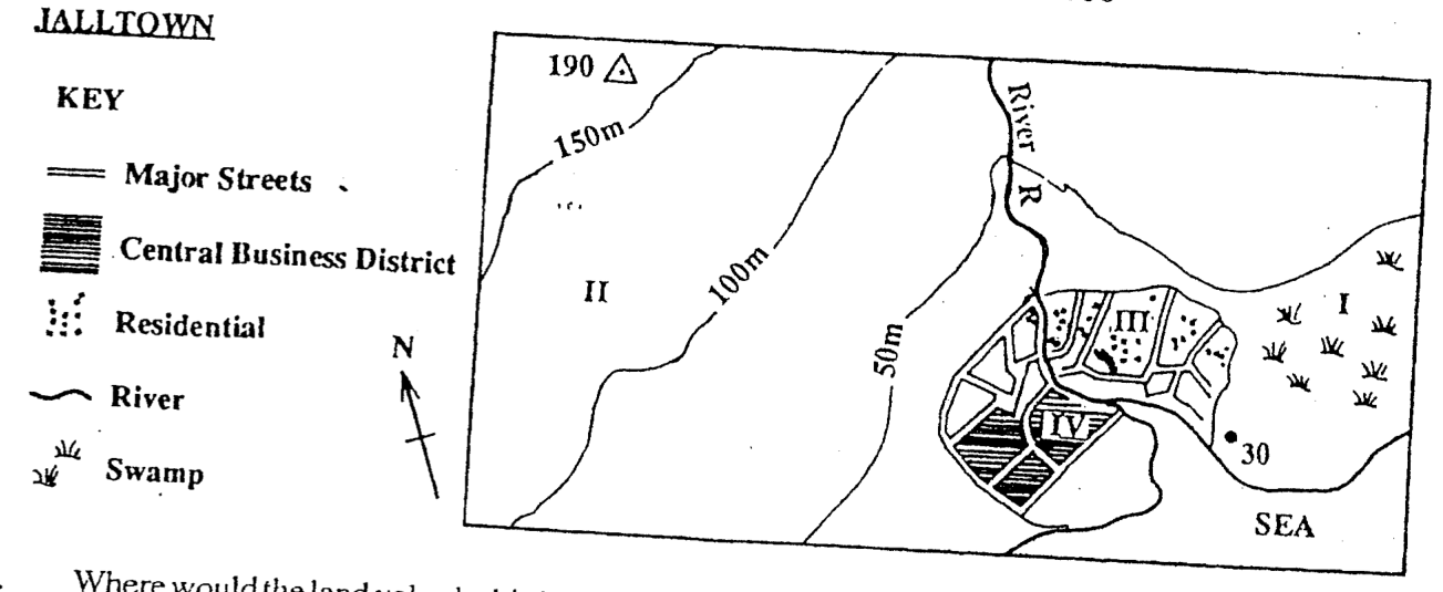
Items 16-17 refer to the following map extract at a scale of 1 : 100 000
Where would the land value be highest on the map extract?
I
II
III
IV
What is the gradient of the slope from the spot height (30) to the trigonometrical point (190)?
1 in 5
1 in 50
1 in 500
1 in 5 000
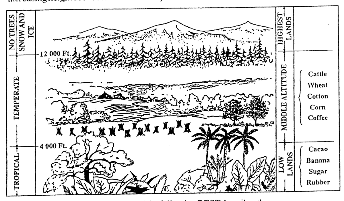
Item 18 refers to the following diagram which shows climate, products and vegetation with increasing height above sea level in the tropics.
Which of the following BEST describes the conditions illustrated in the diagram above?
Near the equator, climates and prod- ucts vary according to altitude.
The area near to the equator has many mountains.
Few products are grown in temper- ate regions.
Vegetation is more abundant in the highland areas than in the lowland areas.
Where in the Caribbean will elfin woodland be found?
In the hot, wet lowlands or plains
On the windward side of mountains
At altitudes of over 2,000 m above sea level
In very dry places such as in the 'rain shadow' of mountains
Which of the following factors have influ- enced the development of dairying in the Caribbean? I. High quality breed of animals II. Increasing imports of cattle feed III. Establishment of milk processing plants IV. Improved quality of grass
I, II and III only
I, II and IV only
I, III and IV only
II, III and IV only
Which of the following aspects of wind is measured by a wind vane?
Direction
Height
Speed
Force
Which of the following elements of climate does the Six's thermometer measure?
Air pressure
Cloud cover
Temperature
Humidity
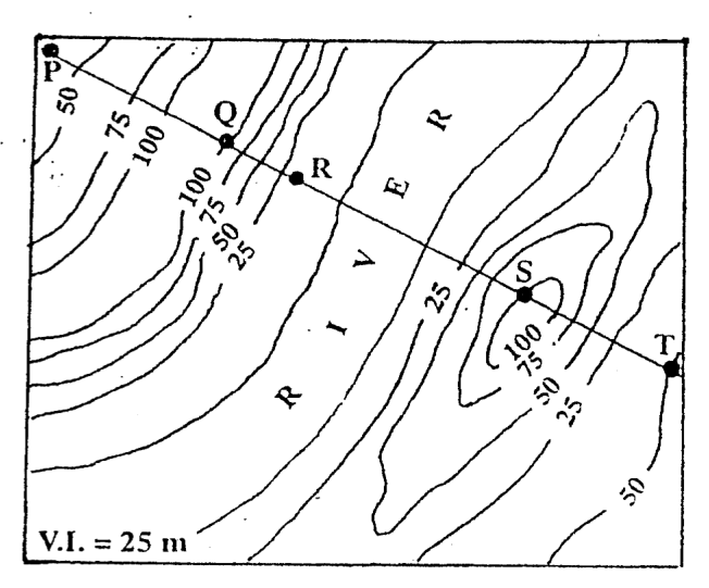
Items 23-24 refer to the following contour map. V.I. = 25 m
Which of the following pairs of points is intervisible according to the contour map above?
P and T
Q and S
P and S
Q and T
Between which of the following pairs of points is the steepest gradient?
P and Q
R and S
Q and R
S and T
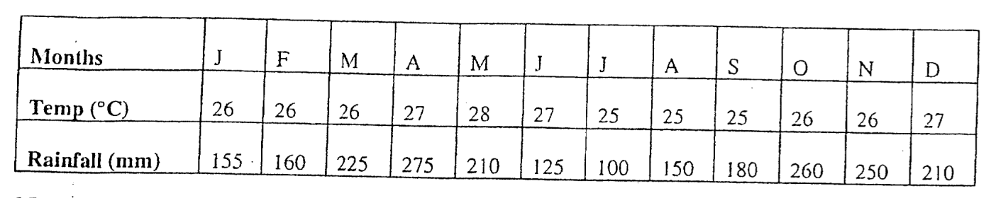
Items 25-27 are based on the following table which shows annual rainfall and temperature figures for a certain location. Months J F M A M J J A S Ο N D Temp (°C) 26 26 26 27 28 27 25 25 25 26 26 27 Rainfall (mm) 155 160 225 275 210 125 100 150 180 260 250 210
The annual temperature range shown above is
2°C
3°C
25°C
27°C
The rainfall distribution may be described as
rain throughout the year
rain only in the cooler season
rain only in the warmer season
no variation in the rainfall from one month to the next
The climatic type shown above is known as
Tropical Continental
Tropical Marine
Equatorial
Cool Temperate Interior
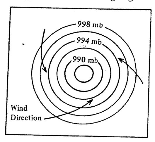
Item 28 refers to the following diagram. Wind Direction 998 mb 994 mb. 990 mb.
The diagram above shows that winds are blowing
inwards and anti-clockwise towards a high pressure centre
outwards and clockwise towards a low pressure system
inwards and anti-clockwise towards a low pressure centre
outwards and clockwise towards a high pressure system
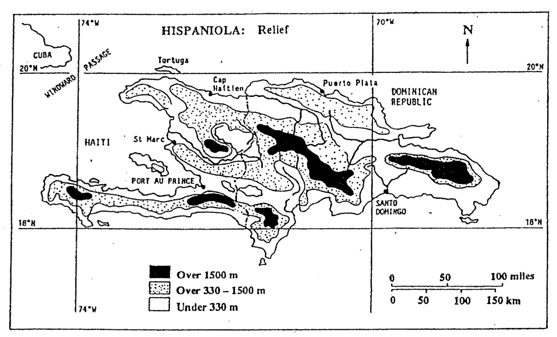
Items 29-30 refer to the following map.
An aircraft flying directly to Cap Haitien from Santo Domingo will travel approximately
185 km (116 miles)
270 km (169 miles)
300 km (188 miles)
380 km (237 miles)
Which of the following pairs of towns is located at approximately the same latitude?
St. Marc and Santo Domingo
Port-Au-Prince and Santo Domingo
Port-Au-Prince and Cap Haitien
St. Marc and Cap Haitien
Which of the following sources of energy is LEAST likely to harm the environment?
Gasolene
Kerosene
The sun
Natural gas
Which of the following is NOT a feature of Equatorial Forests?
Evergreen, dense and of a great variety
Trees of different heights forming layers
Vast tracts and stands of softwoods
Little undergrowth and numerous climbing plants
The term 'soil texture' refers to
grain size
humus content
water content
living organisms
The rearing of animals mainly for meat and hides is BEST described as
dairy farming
livestock farming
mixed farming
arable farming
The main function of MOST Central Business Districts of Caribbean cities is
commercial
manufacturing
recreational
residential
Which of the following areas experience a Tropical Marine Climate?
South-West Australia and South-West Africa
Brazilian Highlands and Northern Australia
South China and Northern Australia
Jamaica and coastal Central America
Which of the following explains why fresh flowers must be exported by air?
Flowers are light in weight.
Air transport prevents loss of colour.
Flowers are expensive to produce.
Flowers are perishable products.
Which of the following statements does NOT apply to the forests of the Caribbean region?
Trees prevent soil erosion.
Wooded areas help to conserve the water supply.
Forests are major suppliers of pulp to the paper industries
Forests provide a valuable source of timber.
Hurricanes are very damaging to low-lying coastal areas such as around bays and gulfs mainly because of the
flooding brought on by storm surges
heavy rainfall such as 250mm in four days
strong winds reaching speeds of up to 300 km per hour
flat lands which cannot act as a barrier for the hurricane
Which of the following resources can be considered non-renewable?
Off-shore fisheries
Water
Bauxite
Mahogany trees
Which of the following relief features is a result of plate tectonic activity in the Caribbean?
Rupununi Savannas - Guyana
Soufrière - St. Vincent
Aripo Plains - Trinidad
Palisadoes Spit - Jamaica
Which of the following species of trees is NOT native to the Caribbean?
Mahogany
Greenheart
Purpleheart
Teak
Which of the following are methods used by Caribbean governments to improve farming in the Region? I. Providing more land to small farmers for food production II. Providing loans for the purchase of fertilisers and machinery III. Encouraging food processing to supply the local and regional markets IV. Exposing the farmers to improved methods of farming
I and II only
II, III and IV only
III and IV only
I, II, III and IV
In an anticyclone very little rainfall occurs MAINLY because the
winds are very weak
air is drifting downwards
pressure gradient is gentle
temperature is low
Plants which are adapted to living in dry conditions are referred to as
epiphytes
lianas
parasites
xerophytes
Which of the following factors are MOST likely to result in urban growth in the Caribbean?
I. Urban to rural migration II. Rural to urban migration III. High death rate and low birth rate IV. Low death rate and high birth rate
I and IV only
I and III only
II and III only
II and IV only
The natural increase of a population is a result of
higher birth rate than death rate
lower birth rate than death rate
net immigration
net emigration
Agriculture which involves the periodic cutting and burning of vegetation is termed
nomadic farming
dry farming
subsistence farming
shifting cultivation
Which of the following factors have influenced the location of MOST port cities in the Caribbean? I. Low land II. A good harbour III. Accessibility to the interior IV. The prevailing winds
I and IV only
II and III only
I, II and IV only
I, II, III and IV only