Free CXC Geography Paper 1 May/June 2014 past paper from 2014. Includes a worked answer key. Open the PDF, take a timed test, and study with AI on Caribbean AI.
Answer keys are free on Caribbean AI. View the answers to every past-paper question at no cost - no payment needed - with step-by-step worked solutions and instant AI marking available on Premium.
CSEC Geography Paper 1 May/June 2014 - Free CXC Past Paper with Answers
Free CXC Geography Paper 1 May/June 2014 past paper from 2014. Includes a worked answer key. Open the PDF, take a timed test, and study with AI on Caribbean AI.
Opening the interactive papers…
Every question from this paper as text. See the answers and worked solutions. Questions are the property of the Caribbean Examinations Council; Caribbean AI is not affiliated with CXC.
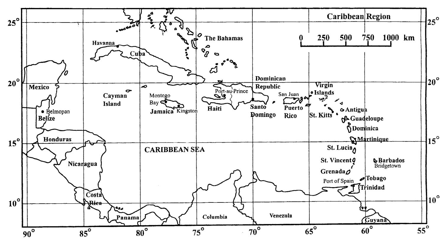
Items 1–5 refer to the map of the Caribbean Region.
Which country is located at 13°N 59°W?
St Lucia
Trinidad
Barbados
St Vincent
Santo Domingo is located at
18 °S 70 °W
18 °N 70 °W
20 °N 70 °E
22 °N 70 °W
Which city is located 1000 km from Montego Bay?
Havana
Belmopan
Port-au-Prince
Santo Domingo
An airplane leaves San Juan, Puerto Rico, for Barbados. In which general direction will it fly?
South west
South east
North west
North east
If the time in Belmopan is 3.00 p.m., what is the time in Santo Domingo?
2.00 a.m.
2.00 p.m.
4.00 a.m.
4.00 p.m.
Items 6-7 refer to the statement below. The horizontal distance between two points, on a slope, is 400 m and the difference in height is 80 m.
What is the gradient of the slope?
1 in 5
1 in 8
1 in 10
1 in 20
The gradient can be described as
steep
gentle
gradual
moderate
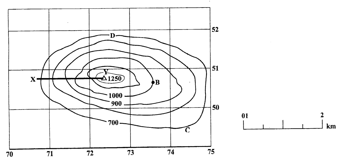
Items 8-9 refer to the sketch map below.
What is the type of slope at XY?
Terraced
Scarp
Concave
Convex
What is the grid reference for the point B?
506737
516736
736507
745513
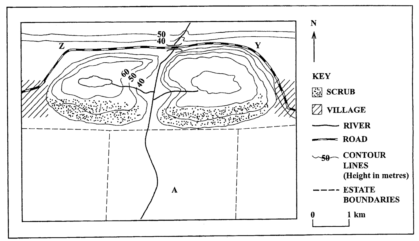
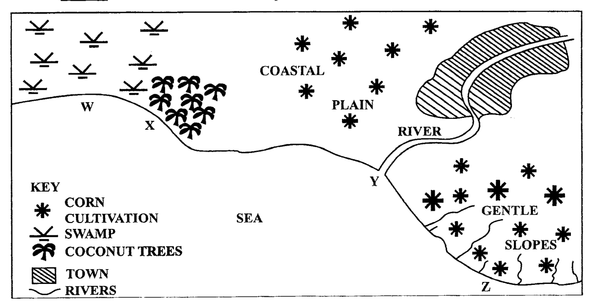
Items 10-11 refer to the following map.
Which of the following types of settlement will MOST likely develop between points Y and Z?
Linear
Isolated
Dispersed
Nucleated
The type of farming system which is MOST likely to exist at A is
poultry rearing
shifting cultivation
subsistence farming
large-scale commercial
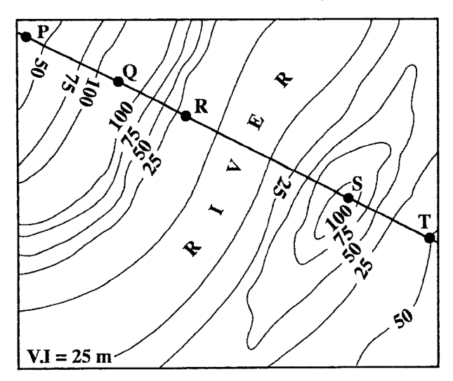
Items 12-13 refer to the following contour map. V.I = 25 m
Which of the following pairs of points is intervisible according to the contour map above?
P and T
Q and S
P and S
Q and T
Between which of the following pairs of points is the gradient STEEPEST?
P and Q
R and S
Q and R
S and T
Items 14-15 are based on the following table showing annual rainfall and temperature figures for a certain location.
The annual temperature range shown above is
2°
3°
25°
27°
The climatic type shown above is called
Savanna
Equatorial
Tropical Marine
Tropical Continental
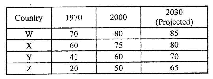
Items 16-17 refer to the following table which shows the percentage of total population in urban areas. Country 1970 2000 2030 (Projected) W 70 80 85 X 60 75 80 Y 41 60 70 Z 20 50 65
In which country is urbanization occurring the FASTEST?
W
X
Y
Z
Which of the following presentations is MOST suitable for the information in the table above?
Isoline
Dot map
Bar graph
Pie chart
The single most important difference between weather and climate is the
statistical method used
length of time considered
size of the region studied
type of atmospheric elements considered
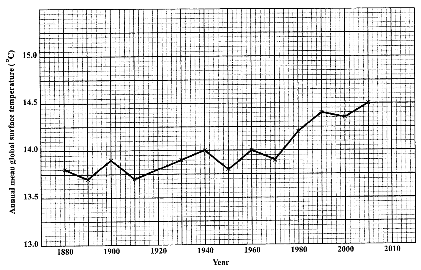
The LARGEST change in the annual mean global temperatures occurred over the period
1890-1910
1920-1940
1950-1970
1970-1990
The general trend of the annual mean global temperatures shown in the graph above is
a decrease in temperatures
an increase in temperatures
a consistency in temperatures
a great fluctuation in temperatures
What degree of change in global temperatures was recorded between 1910 and 1940?
0.2
0.3
0.4
0.5
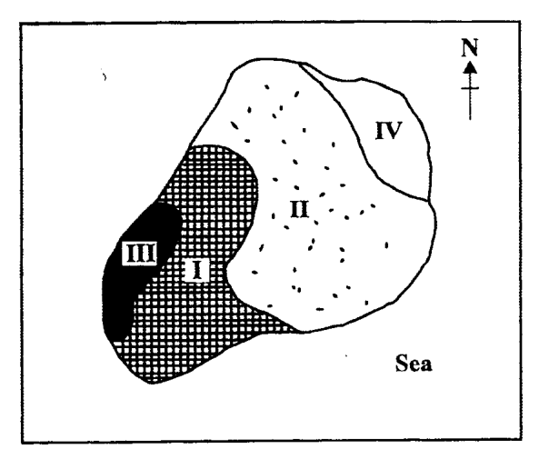
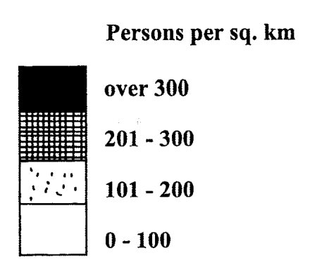
Items 22-23 refer to the diagram below.
Which part of the island (I, II, III or IV) has the SMALLEST population?
I
II
III
IV
The map above shows population
change
density
movement
distribution
A volcanic spine develops when
the lava is viscous
a caldera is present
the explosion is violent
ash and cinder are ejected
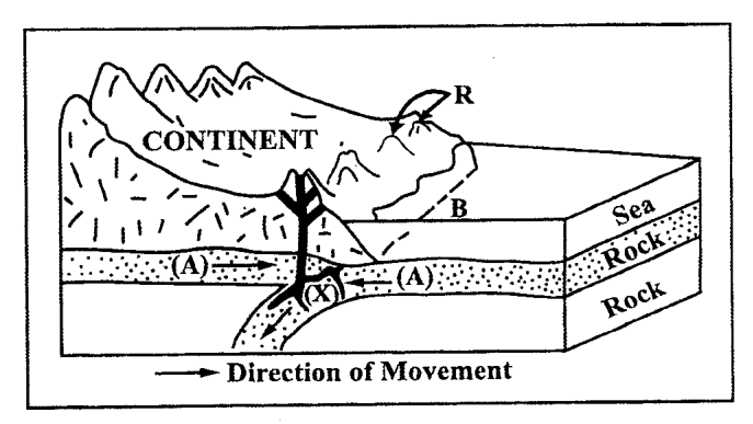
Subduction occurs at
mid-oceanic ridges
divergent plate boundaries
transform plate boundaries
convergent plate boundaries
The features shown at R are
volcanoes
fold mountains
block mountains
volcanic island arcs
Which of the following plate margins is shown?
Divergent
Transform
Convergent
Conservative
Which of the following statements is true of ALL volcanoes?
I. Various gases are emitted during the eruption. II. They occur at weak points in the crust. III. Their eruptions are violent.
I and II only
I and III only
II and III only
I, II and III
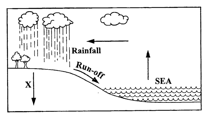
Items 29-30 refer to the diagram below.
What does X represent in this diagram?
Percolation
Evaporation
Precipitation
Transpiration
The diagram above represents the process in
relief rain
a drainage basin
cyclonic rain
the hydrologic cycle
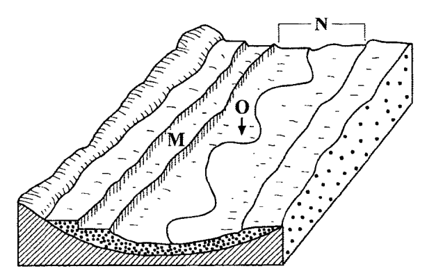
Items 31-32 refer to the following diagram.
The feature at M is a
levée
terrace
waterfall
flood plain
Which of the following features forms in the area marked N?
A levée
A plateau
A flood plain
An alluvial fan
Deposition by a river usually occurs when its
volume increases
capacity increases
gradient increases
velocity decreases
Which of the following features is an intrusive volcanic feature?
Sill
Crater
Caldera
Lava plateau
Which of the following types of settlement will MOST likely develop at a road junction?
Linear
Isolated
Nucleated
Dispersed
Which of the statements below may explain why some areas in Caribbean territories are sparsely settled?
I. They are hilly and forested. II. They have no mineral resources. III. Transport links are generally poor.
I and II only
I and III only
II and III only
I, II and III
Why has there been a decline in the population within the municipal boundaries of MOST capital cities in the Caribbean?
I. Land has been redeveloped for business. II. The residential environment has deteriorated. III. The number of factories has increased.
I and II only
I and III only
II and III only
I, II and III
Which of the following explains the population growth in urban centres in the Caribbean?
An ageing population
An increase in emigration
High birth and death rates
Migration from rural areas
Which of the following statements is TRUE of peasant farming?
Individual farms are small.
Yields per farmer are generally high.
Large amounts of fertilizers are used on the farm.
Crop cultivation is not as important as animal rearing.
Rapid urbanization in Caribbean countries USUALLY resulted in
housing shortages in the cities
increased employment in the cities
improvement in the standard of living
decreased foreign exchange earnings
Which of the following is classified as a tertiary industry?
Fishing
Tourism
Oil refining
Food processing
Which of the following have resulted from the setting up of secondary industries in the Caribbean?
I. Increased external markets II. Reduction in the cost of living III. Increased employment opportunities
I and II only
I and III only
II and III only
I, II and III
Which of the following measures do governments use to influence the location of industries?
I. Provision of tax incentives II. Offer of training programmes to employees III. Provision of the necessary infrastructure
II only
I and II only
I and III only
II and III only
Which of the following is the MOST serious problem hindering rapid agricultural development in the Caribbean?
Lack of capital
Rapid soil erosion
The lack of crop variety
A high incidence of crop disease
Which of the following would NOT be classified as arable farming?
Fruit farming
Cattle ranching
Market gardening
Sugar cane growing
Which of the following methods are used by Caribbean governments to improve farming in the region?
I. Providing more land to small farmers for food production II. Providing loans for the purchase of fertilisers and machinery III. Encouraging food processing to supply the local and regional markets
I and II only
I and III only
II and III only
I, II and III
Which of the following is the MOST important consideration in the location of primary industries?
Power
Labour
Transportation
Raw materials
Which of the following are problems affecting industrial development in the Caribbean?
I. A large labour force II. Limited capital III. Limited raw materials
I and II only
I and III only
II and III only
I, II and III
Which of the following is a form of air pollution?
Smog
Oil spill
Raw sewage
Mercury poisoning
Which of the following poses the MOST serious threat to the rivers of the Caribbean?
Tourist activities
Mixed cropping
Deforestation and erosion
Improper fishing in them
Which of the following usually cause/causes coastal pollution in the Caribbean? I. Oil spills from ocean-going vessels II. Poisonous fumes from iron and steel plants III. Discharge of waste material into rivers
I only
II only
I and II only
I and III only
Which of the following sources of energy is LEAST likely to harm the environment?
Oil
Nuclear
Solar
Natural gas
Which of the following sequences USUALLY occurs where soil erosion is a problem?
Increased run off decreased infiltration deforestation soil erosion
Deforestation decreased infiltration increased run off soil erosion
Deforestation increased infiltration increased run off soil erosion
Increased run off deforestation decreased infiltration soil erosion
Which of the following practices may help to eliminate problems of pollution created by household waste?
Depositing in the sea
Piling up in secluded spots
Dumping along water courses
Burying and covering with soil
Which of the following exerts the GREATEST pulling effect on tourism in the Caribbean?
Climate
Carnival
Coral reef
Tropical forest
Which of the following will control water pollution along the coast shown on the map? I. Treatment of sewage II. Hygienic disposal of domestic waste III. Removal of swamp vegetation
I and II only
I and III only
II and III only
I, II and III
Which of the following can pollute the underground water supply? I. Mulch II. Pesticides III. Chemical fertilizers
I and II only
I and III only
II and III only
I, II and III
Which of the following contributes MOST to pollution of the environment of capital cities in CARICOM?
Discharge of chemicals into the sea
Discharge of fish waste in the sea
Exhaust fumes from motor vehicles
Accumulation of garbage from factories
Which of the following practices may harm the marine environment of the Caribbean? I. Zoning of marine activities II. Harvesting of coral formations for souvenirs III. Discharging sewage and industrial waste along the shore
I only
I and II only
I and III only
II and III only
Which combination of factors would MOST likely result in flooding? I. Soil conservation methods in use II. Deforestation III. Dumping of garbage in rivers
I and II only
I and III only
II and III only
I, II and III