Free CXC Geography Paper 1 May/June 2008 past paper from 2008. Includes a worked answer key. Open the PDF, take a timed test, and study with AI on Caribbean AI.
Answer keys are free on Caribbean AI. View the answers to every past-paper question at no cost - no payment needed - with step-by-step worked solutions and instant AI marking available on Premium.
CSEC Geography Paper 1 May/June 2008 - Free CXC Past Paper with Answers
Free CXC Geography Paper 1 May/June 2008 past paper from 2008. Includes a worked answer key. Open the PDF, take a timed test, and study with AI on Caribbean AI.
Opening the interactive papers…
Every question from this paper as text. See the answers and worked solutions. Questions are the property of the Caribbean Examinations Council; Caribbean AI is not affiliated with CXC.
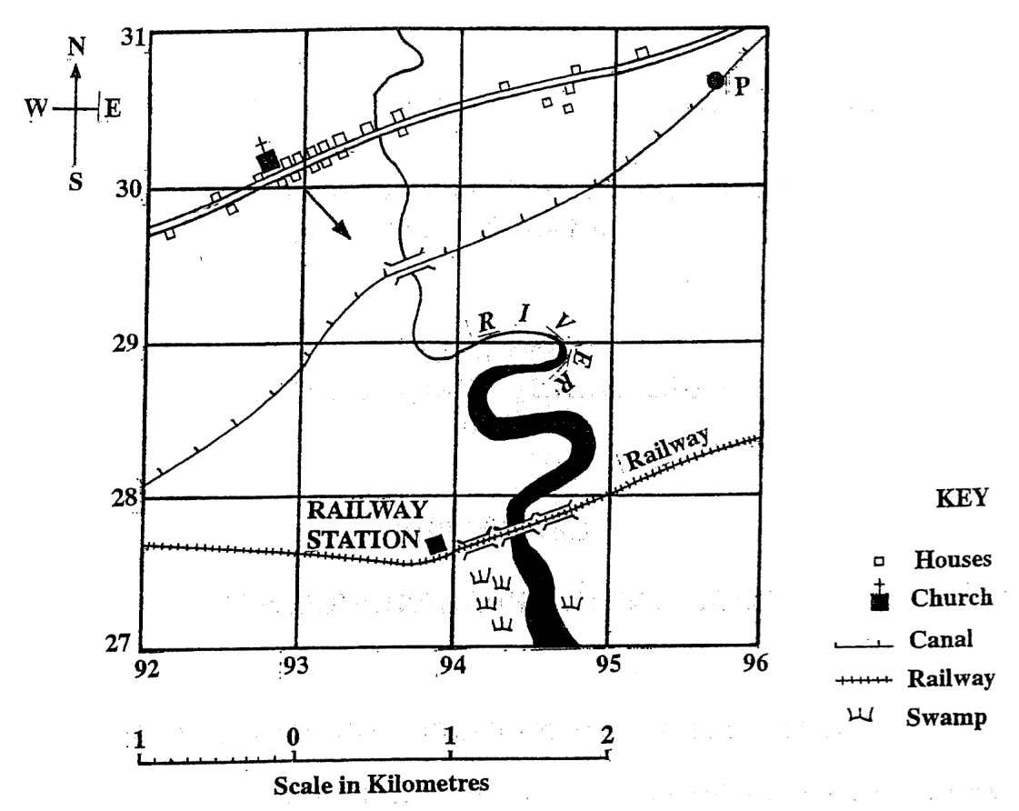
Items 1-5 refer to the following map.
What is the grid reference of Point P?
307957
305954
954305
957307
The straight-line distance, in km, between the church and the railway station is
2.2
2.8
3.0
3.8
In which direction is the arrow on the map pointing?
South-east
South-west
East-south-east
South-south-east
The man-made feature running south-west through P is a
road
canal
railway
swamp
The settlement pattern in the map is BEST described as being
linear
isolated
dispersed
nucleated
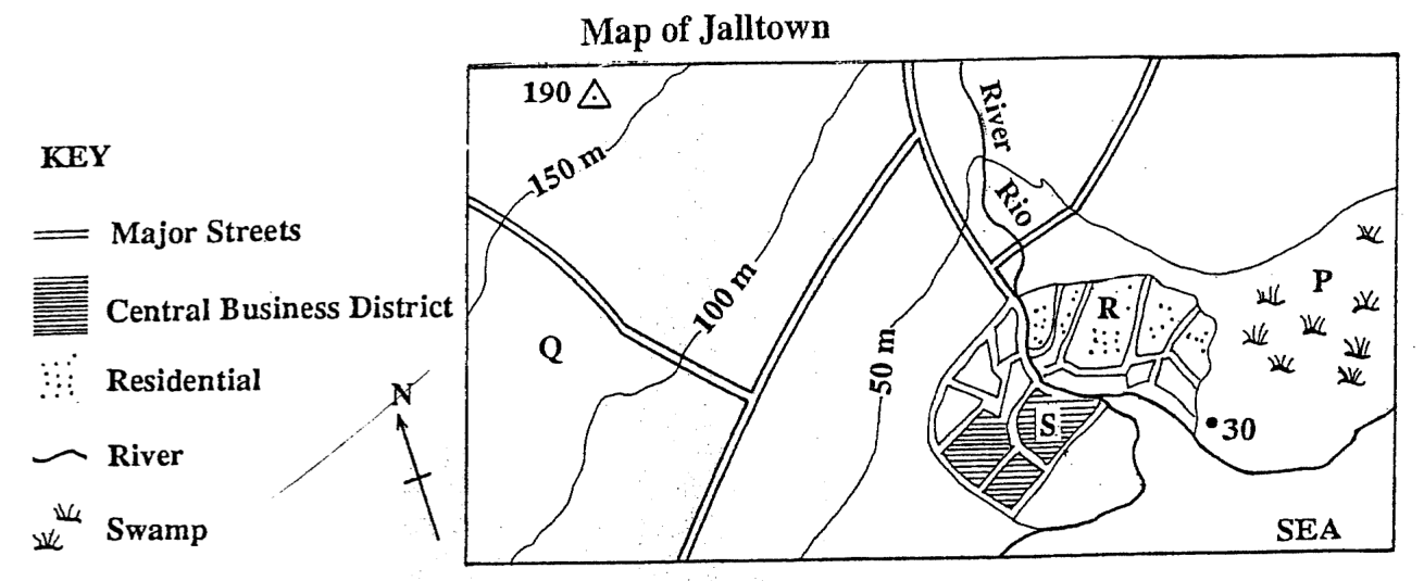
Items 6-10 refer to the following map extract on a scale of 1 : 100 000 Map of Jalltown KEY Major Streets Central Business District Residential River Swamp
Which of the following features of Jalltown are the BEST reasons for its location? I. It is on flat land. II. It has a supply of fresh water. III. It is near to the swamp. IV. It is on the sea coast.
I, II and III only
I, II and IV only
II, III and IV only
I, II, III and IV
A prospective buyer of a house is BEST advised to search in area
P
Q
R
S
What is the general direction of flow of the river shown in the diagram above?
West to east
East to west
South to north
North to south
The width of the contour interval is
50 m
100m
between 50 and 150 m
between 50 and 190 m
Where would the land value be HIGHEST on the sketch map?
P
Q
R
S
What time is it likely to be at Town X (15°E) when it is 10 a.m. at Greenwich (0°)?
9.00 a.m.
9.30 a.m.
10.30 a.m.
11.00 a.m.
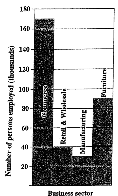
What is the TOTAL number of persons employed in the manufacturing and furniture sectors?
90 000
100000
120000
130000
According to the information from the bar graph above which of the following is NOT true?
The manufacturing sector employs the least number of people.
More than one-half of the entire business sector is employed in commerce.
The retail and wholesale sector employs less than half of the number of people employed in furniture.
The two sectors, furniture, and retail and wholesale, employ more people than commerce.
What is the TOTAL number of persons employed in the four sectors shown in the bar graph above?
310000
320000
330000
350000
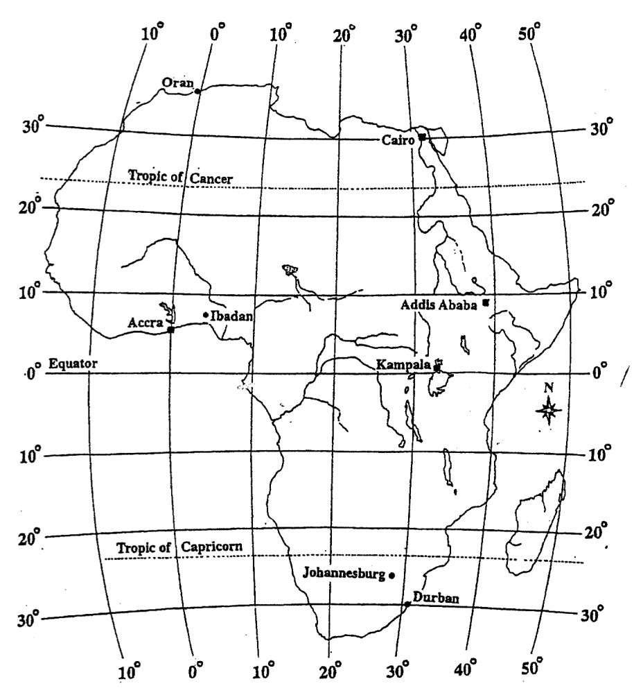
Items 15-16 refer to the following map:
The MOST accurate location for the city of Durbanis
Latitude 30°S, longitude 31°E
Latitude 31°S, longitude 29°E
Latitude 29°N, longitude 29°W
Latitude 29°N, longitude 31°W
Which of the following cities lie South of 0° latitude? I. Oran II. Accra III. Durban IV. Johannesburg
I and III only
III and IV only
II, III and IV only
I, II, III and IV
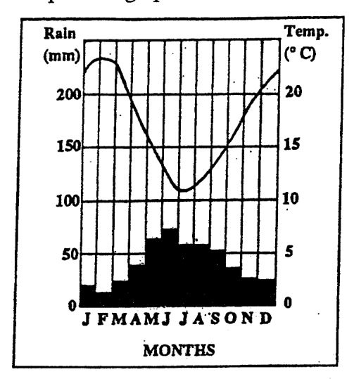
Items 17-19 refer to the rainfall and temperature graph below. Rain (mm) 200 Temp. (°C) 20 150 15 100 10 50 5 0 0 JFMAMJ JASOND MONTHS
The TWO wettest months of the year indicated in the graph shown above are
May and June
July and August
January and February
November and December
The annual range of temperature is approximately
3°C
5°C
12°C
19°C
Which of the following statements is true?
The hottest months of the year are also the driest.
The hottest months of the year are also the wettest.
There is little variation in temperature throughout the year.
There is little variation in rainfall throughout the year.
Isobars are lines drawn on a map which join places experiencing the same
annual rainfall
relative humidity
atmospheric pressure
mean annual temperature
The formation of young fold mountains is NOT explained by
upwelling of magna to form new plates
deposition of sediments in a shallow basin
compression of sediments by colliding plates
elevation of sediments into anticlines and synclines
Which of the statements below describes basic lava? I. Flows easily II. Erupts explosively III. Forms a shield volcano IV. Has high percentage of iron
I, II and III
I, III and IV
II, III and IV
All of the above
Sea floor spreading occurs at the
mid-Atlanticridge
Windward Passage
floor of the Puerto Rico trench
junction of the Caribbean and Cocos plates
Which of the following relief features is a result of plate tectonic activity in the Caribbean?
Aripo Plains in Trinidad
Soufrière in St. Vincent
Palisadoes Spit in Jamaica
Rupununi Savannas in Guyana
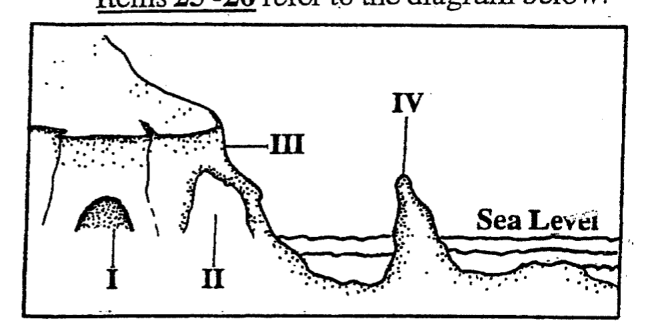
Items 25-26 refer to the diagram below. IV III Sea Level II I
The CORRECT order of the features identified by I, II, III, IV, on the diagram above is
Cave, arch, cliff, stack
Arch, cave, stack, cliff
Stack, cliff, arch, cave
Cliff, cave, stack, arch
Which of the following processes is NOT likely to be an important agent in the formation of the labelled features, I, II, III, IV, on the diagram above?
Abrasion
Corrosion
Deposition
Hydraulic action
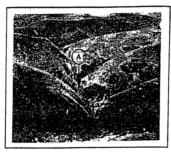
Items 27-28 refer to the photograph below. A
The valley labelled A in the photograph above is MOST likely formed as a result of
folding
faulting
running water
mass movement
Which of the following BEST describes the pattern formed by the sides of the valley in the photograph above?
Meanders
Terraces
Knick-points
Interlocking spurs
Which one of the following groups contains ONLY processes of wind erosion?
Abrasion, deflation, attrition
Corrosion, attrition, plucking
Plucking, corrosion, deflation
Deflation, abrasion, hydraulic action
Which of the following conditions may result from man's utilization of the natural environment?
I. Soil erosion II. Pollution III. Depletion of natural resources
I and II only
II and III only
I and III only
I, II and III
Which of the following statements is NOT true about waves?
They are caused by wind blowing over the surface of the water.
On nearing the beach, the speed of waves slackens and the tops are thrown forward.
The body of water forming the waves increases rapidly as it approaches the coast.
The stronger the wind and the greater the fetch, the more powerful the waves are.
It is most likely that recent hurricanes in the Caribbean have caused fewer deaths because
families no longer live in unsafe areas
many hurricanes have occurred during the day
the majority of the population goes to storm shelters
there have been improved forecasts of hurricane tracks
The process in which water vapour cools and forms water droplets is termed
convection
evaporation
precipitation
condensation
The MOST important factor explaining the difference between weather and climate is
time
location
rainfall
temperature
Tropical or easterly waves in the Caribbean are MOST common during the months
June to July
May to October
December to March
November to December
Four climatic features are listed below.
I. Low pressure all the year around II. High annual rainfall, mostly convectional III. Small annual range of temperature IV. High average daily temperature
Which of the following climatic types is characterised by ALL of the features described above?
Equatorial
Tropical Marine
Tropical Continental
Cool Temperature Interior
The concentration of minerals in the lower layers of a soil profile is the result of
erosion
leaching
capillarity
illuviation
Which of the following is NOT likely to result from slash and burn agriculture on steep slopes?
Erosion of slopes
Flooding on lowlands
Deeper soil on slopes
Rapid downhill movement of water
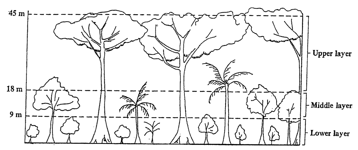
Items 39-40 refer to the diagram below which shows the three layers in an Equatorial Forest.
Plants which grow in the lower layer are adapted to growing in
low humidity
shaded areas
bright sunlight
windy conditions
The trees which grow in the upper layers have buttress roots MAINLY because the
trees are tall
rainfall is heavy
temperatures are high
creepers grow around the trees
Which of the following are ways in which natural vegetation adapts to climatic conditions? I. Development of water-storage organs II. Shedding of leaves during the dry season III. Development of long roots IV. Development of special types of leaves
I and II only
III and IV only
I, II and III only
I, II, III and IV
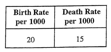
Island B has an area of 20 km² and a population of 1000 people. What is the population density of Island B?
per km²
50 per km²
500 per km²
20 000 per km²
For 2000, the natural increase in Country A is
0.005%
0.5%
5.0%
3.5%
Which of the following areas would have its HIGHEST population density in the daytime?
A squatter settlement
A rural fishing village
A suburban residential area
An urban commercial centre
Which of the following terms BEST explains the rapid growth in size of MOST urban centres in the Caribbean?
An ageing population
The migration of persons from rural areas
High birth rates and low infant mortality
An increase in the number of immigrants
Which of the following features are characteristic of peasant farms in the Caribbean?
I. Small holdings II. Large holdings III. Family labour IV. Local market
I and III only
I and IV only
I, III and IV only
II, III and IV only
Which of the following statements is true of subsistence farming?
Individual farms are quite small.
Yields per farmer are generally high.
Large amounts of fertilisers are used on the farm.
Crop cultivation is not as important as animal rearing.
Commercial pastoral farming in Caribbean territories is LEAST likely to take place near urban settlements because
there are no large areas of land for grazing
the soil in these locations is infertile
the size of population is too small to support this activity
animal diseases are easily passed on to humans
Which of the following factors has NOT contributed to the development of the garment industry in the Caribbean?
Availability of local raw materials
Incentives by local governments
The need for more job opportunities
The presence of local and regional markets
Which of the following considerations is LEAST important in choosing a location for a fishing industry?
A large labour force
Nearness to the sea
Adequate marketing facilities
Adequate storage facilities
Which of the following is the MAIN reason why flour mills in the Caribbean are situated on coastal locations?
Availability of cheap labour
Availability of cheap power supply
Nearness to the waste disposal facilities
Nearness to facilities for unloading raw materials
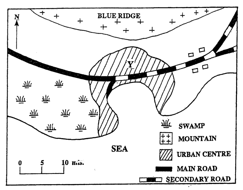
Which of the following features BEST explain why the urban centre in the sketch map above is located at Y?
I. The presence of flat land II. The nearness to the mountains III. The presence of a natural harbour
I and II only
I and III only
II and III only
I, II and III
In which direction is the urban centre MOST likely to expand?
West
East
South
North
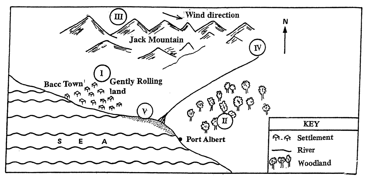
Items 54-55 are based on the following sketch map.
Which of the areas, labelled (I), (II), (III) and (IV), is MOST LIKELY to be developed as a tourist resort?
I
II
IV
V
Which of the areas, labelled (I), (II), (III) and (IV), would be the BEST area for locating a new factory in order to minimize the effects of air pollution?
I
II
III
IV
The main reasons for urbanization in the Caribbean are I. natural increase of the population in the cities II. expectation of more jobs in the cities III. migration from rural areas to urban areas IV. migration from urban areas to rural areas
I and III only
I and IV only
I, II and III only
I, III and IV only
Agriculture is an important economic activity in the Caribbean because
it is heavily mechanized
it employs a significant percentage of people
government allocates a significant portion of its budget to the sector
it accounts for a significant portion of the foreign exchange earnings in many countries
Many garment industries in the Caribbean are closing business MAINLY because
the demand for clothes is falling
cheaper imports are entering the region
the rates for wages are lower in South-East Asia and Mexico
many women refuse to work in the factories
In the long-term, volcanic eruptions can have beneficial effects to a country by I. relocating people to new areas in the country II. producing deposits of gold, copper and other minerals III. providing sources of energy to be used for electricity needs IV. bringing new materials to the earth's surface which produce rich soils
I only
I, II and IV only
I, III and IV only
II, III and IV only
In advance of the approach of a hurricane, risk to lives can be reduced by I. relocating people to shelters II. evacuating people living in low-lying areas III. encouraging people to stock up on fresh supply IV. encouraging people to acquire generators for their energy needs
I and II only
III and IV only
I, II and III only
All of the above