Free CXC Geography Paper 1 May/June 2026 past paper from 2026. Includes a worked answer key. Open the PDF, take a timed test, and study with AI on Caribbean AI.
Answer keys are free on Caribbean AI. View the answers to every past-paper question at no cost - no payment needed - with step-by-step worked solutions and instant AI marking available on Premium.
CSEC Geography Paper 1 May/June 2026 - Free CXC Past Paper with Answers
Free CXC Geography Paper 1 May/June 2026 past paper from 2026. Includes a worked answer key. Open the PDF, take a timed test, and study with AI on Caribbean AI.
Opening the interactive papers…
Every question from this paper as text. See the answers and worked solutions. Questions are the property of the Caribbean Examinations Council; Caribbean AI is not affiliated with CXC.
What is the grid reference of the school (Sch) at Golden Grove?
273426
287434
426273
434287
The general direction of Port Morant from Golden Grove is
northeast
southeast
northwest
southwest
The bearing of the main road junction at Golden Grove from the main road junction at Arcadia Junction (near Easting 24) is APPROXIMATELY
045°
132°
228°
312°
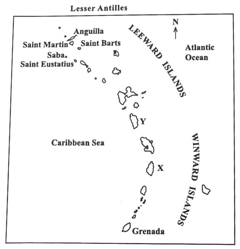
What are the names of the islands labelled X and Y respectively?
Monsterrat and Antigua
Saint Lucia and Dominica
St Vincent and Martinique
Guadeloupe and Barbados
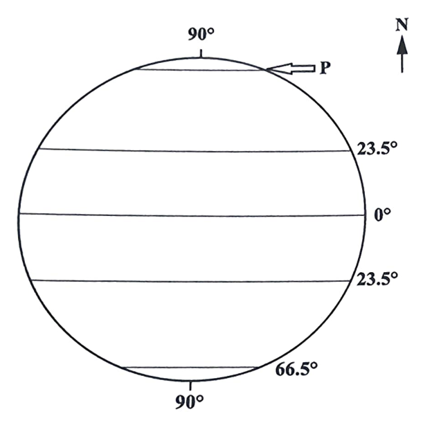
Which line of latitude is labelled P?
North Pole
Arctic Circle
Antarctic Circle
Tropic of Capricorn
The horizontal distance between two points on a slope is and the difference in height is . What is the gradient of the slope?
1 in 5
1 in 8
1 in 10
1 in 20
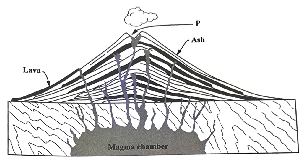
What is the name of the volcanic feature labelled P?
Cone
Crater
Fissure
Caldera
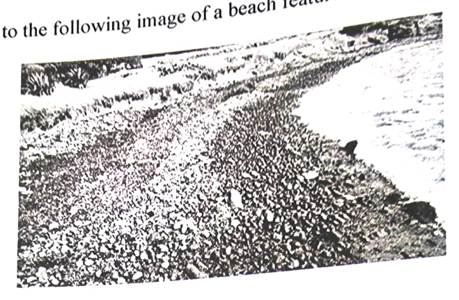
Which of the following features is shown in the image?
Pebble beach
Beach platform
Wavecut terrace
Wavecut platform
Which type of wave MOST likely resulted in the formation of the feature?
Abrasive
Corrosive
Destructive
Constructive
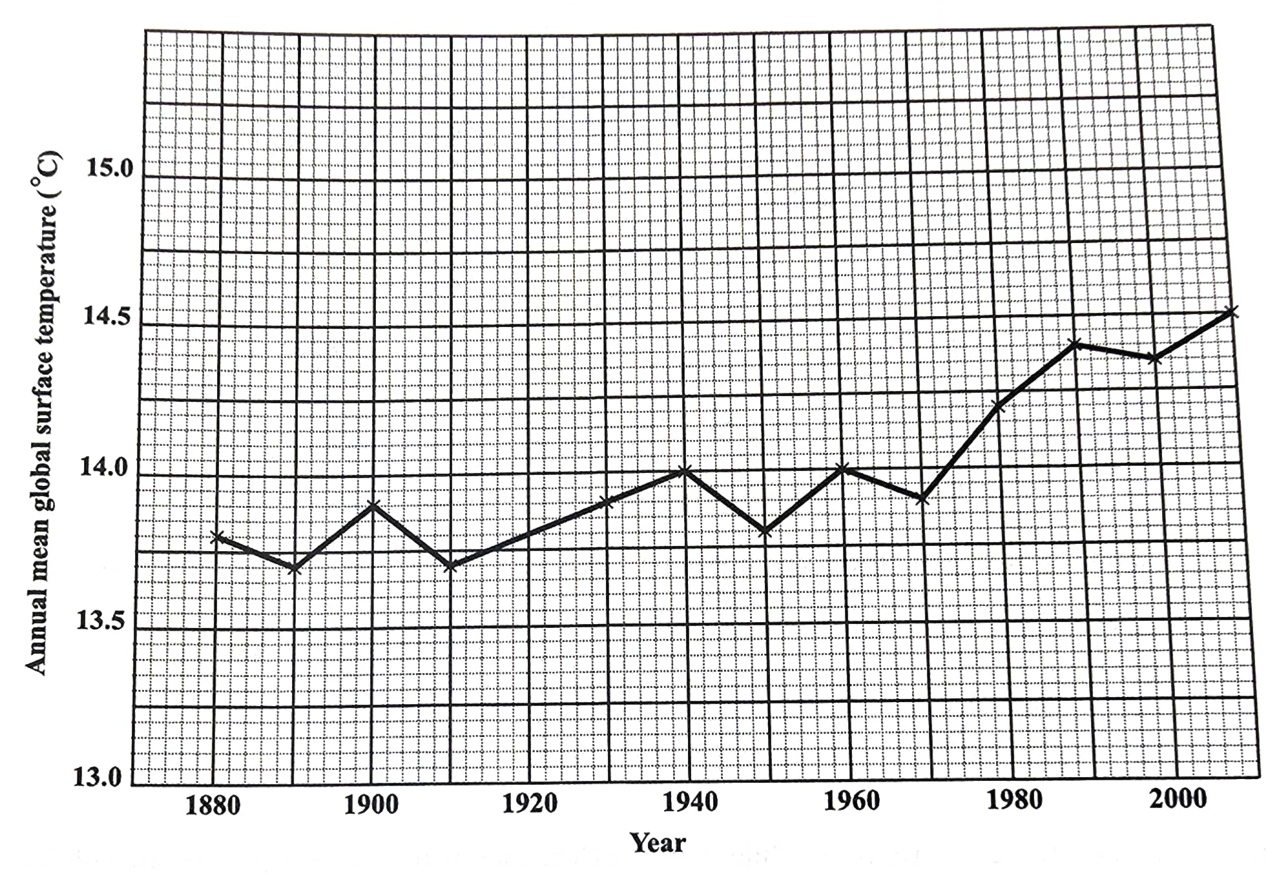
Items 10 and 11 refer to the following graph which shows long-term changes in global temperatures over the last two centuries.
What degree of change in global temperatures was recorded between 1910 and 1940?
0.2
0.3
0.4
0.5
The LARGEST change in the annual mean global temperatures occurred over the period
1890–1910
1920–1940
1970–1990
1980–2000
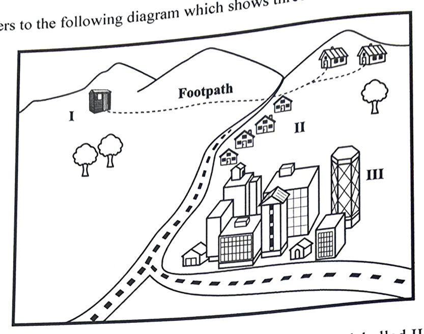
Item 12 refers to the following diagram which shows three settlements labelled I–III.
Which type of settlement would MOST likely form at the point labelled III on the diagram?
Linear
Ribbon
Scattered
Nucleated
When a traveller crosses the International Date Line while going westward, he will have to
add half a day to his calendar
add one full day to his calendar
continue with his calendar as normal
subtract one full day from his calendar
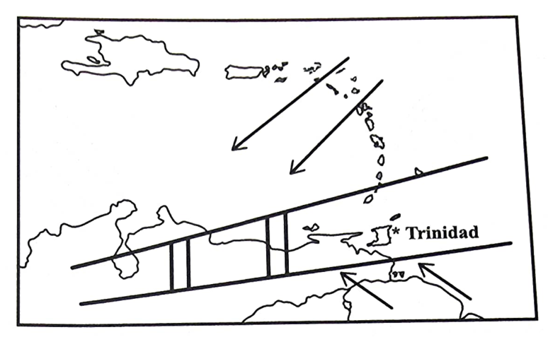
What weather system, shown on the map, is affecting Trinidad?
ITCZ
Anticyclone
Cold front
Tropical wave
Which of the following measurements are taken with a hygrometer, to calculate relative humidity?
Maximum and minimum air temperatures
Temperature and atmospheric pressure
Wet bulb and dry bulb temperatures
Temperature and precipitation
The relationship between longitude and time is that the time changes by
1 hour for
1 minute for
4 minutes for
24 hours for
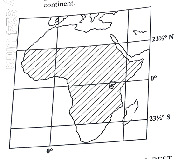
The shaded area on the map above is BEST described as the
Tropics
Arctic Zone
Mediterranean
Temperate Zone
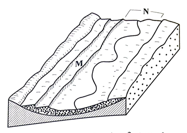
Which of the following features forms in the area labelled N?
Levee
Plateau
Floodplain
Alluvial fan
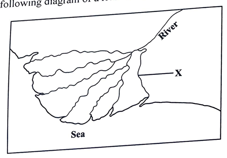
The feature labelled X is a
mouth
tributary
confluence
distributary
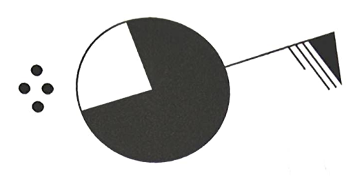
Which of the following represents the cloud cover shown on the station model?
The rainfall shown on the station model is
light
heavy
moderate
intermittent
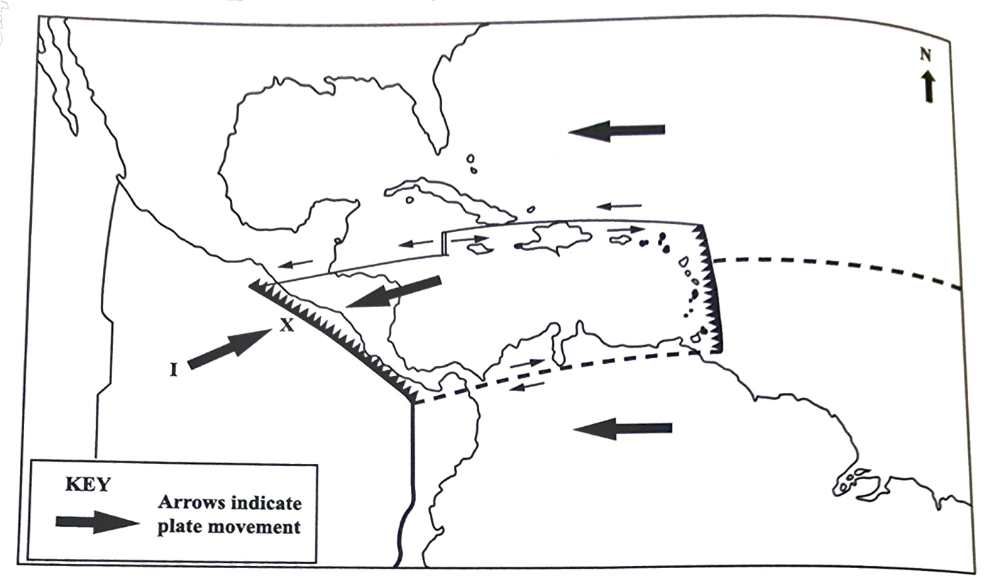
Items 22 and 23 refer to the following map of crustal plates.
The plate labelled I is the
Cocos Plate
Pacific Plate
American Plate
Caribbean Plate
Which type of boundary is formed at X?
Divergent
Transform
Convergent
Constructive
How does vegetation contribute to the development of soils?
It increases the depth of soil.
It decomposes to form humus.
It provides the parent material.
It decomposes to produce inorganic matter.
A river that is wide, shallow and has bars and islands around which the river flows is described as
flooded
braided
turbulent
meandering
Which of the following correctly describes the relationship between weather and climate?
Climate refers to the conditions of the atmosphere whereas weather mainly refers to the seasons.
Weather refers to only cloud cover and winds while climate refers to only temperature and rainfall.
Climate is a changeable, everyday occurrence while weather refers to changes in the atmosphere over a longer time.
Weather is the day-to-day changes in the atmosphere while climate is the average condition of the atmosphere over many years.
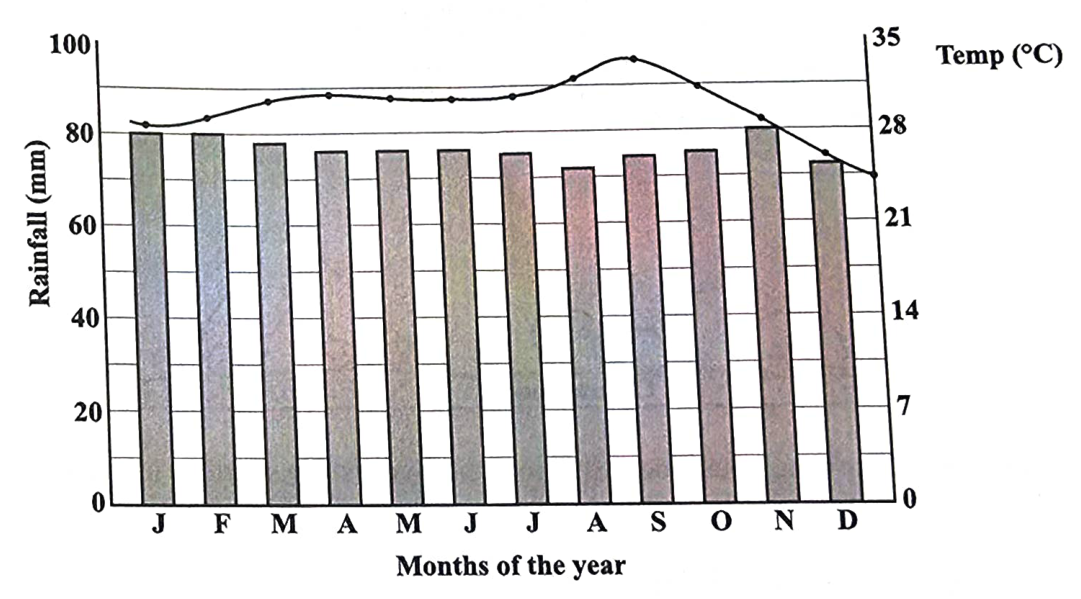
Which of the following types of climate does the information in the diagram represent?
Hot desert
Equatorial
Tropical marine
Tropical continental
Which of the following is an adaptation seen in most trees growing in areas that experience these climatic conditions?
Thick barks
Long, deep roots
Broad, pointed leaves
Seasonal shedding of leaves
In January, the temperature suddenly drops and the wind speed increases; the sky gradually becomes overcast and there is a light shower. What type of weather system is being described?
Hurricane
Cold front
Tropical wave
Intertropical Convergence Zone
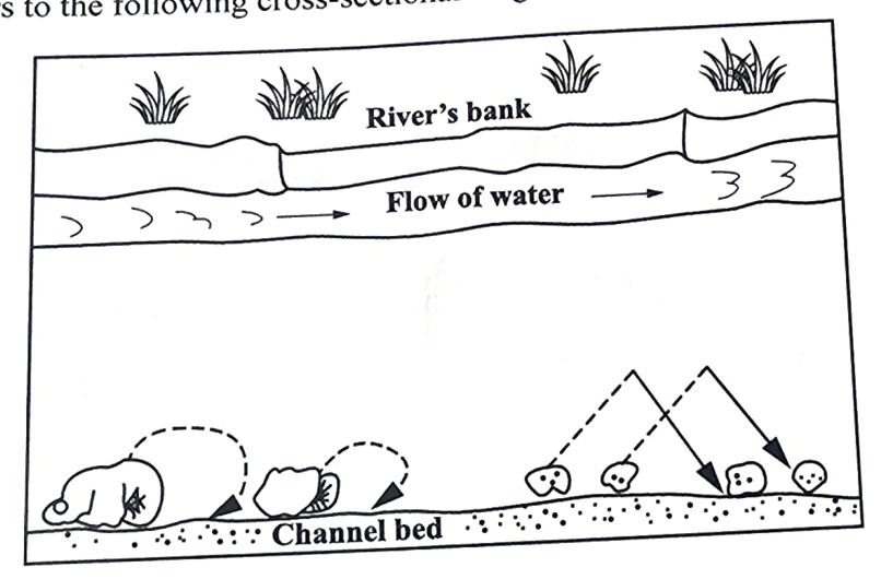
Which of the following BEST describe how the river is transporting its load along the channel bed?
Capillarity and illuviation
Solution and suspension
Traction load and saltation
Hydrolysis and carbonation
When magma emerges on the surface, it may lead to the formation of
sills
dykes
laccoliths
lava flows
Which of the following acids increases the rate of chemical weathering in karst landscapes?
Nitric
Sulfuric
Carbonic
Hydrochloric
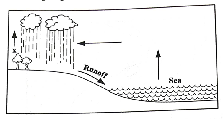
In the diagram, X represents
percolation
evaporation
transpiration
precipitation
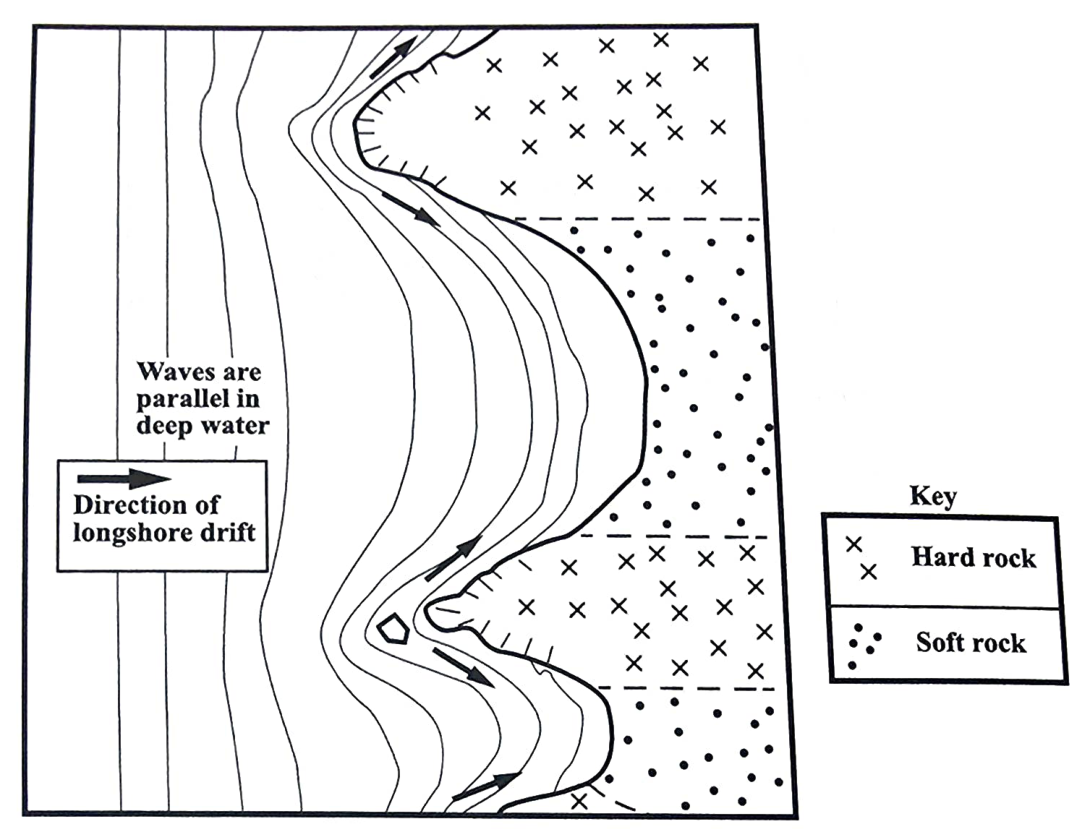
A MAJOR effect of wave refraction along the coastline shown in the diagram is the
eroding of headlands
straightening of the coast
removal of sand from the beach
channelling of caves, arches and stacks
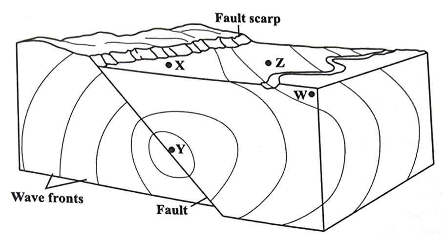
At which of the following points would the waves of the earthquake be felt the strongest?
W
X
Y
Z
Which of the following statements explains why snow may be present on mountaintops in Africa, near the equator?
Jet streams move cold air towards the equator.
The sun's rays are oblique on the mountaintops.
Low pressure systems at the equator lower the temperature.
The mountaintops are cold due to the elevation of these mountains.
Which of the following actions can be taken to reduce the emission of greenhouse gases?
Reduction in the use of energy-efficient technology
Increased use of chlorofluorocarbons (CFCs)
Increased large-scale cattle farming
Increased use of solar power
Which of the following environmental changes in the Caribbean is MOST directly linked to global warming?
Rising sea levels
Bleaching of corals
Increased hurricane intensity
Displacement of coastal communities
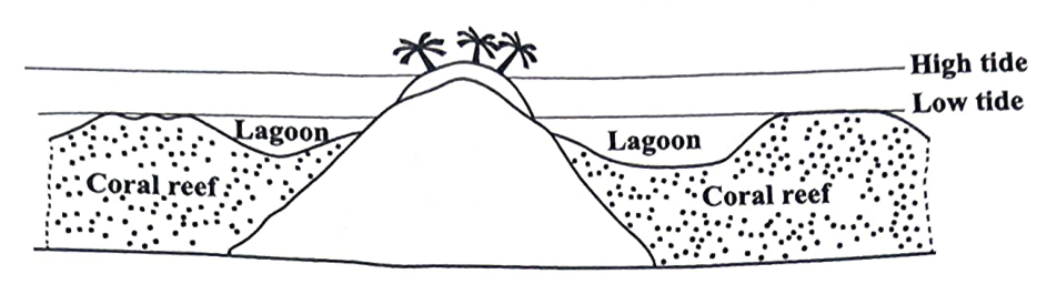
The type of coral reef shown on the map is
an atoll reef
a patch reef
a fringe reef
a barrier reef
Which of the following activities is LEAST likely to benefit from the presence of coral reef?
Fishing
Tourism
Coastal protection
Shipping and maritime
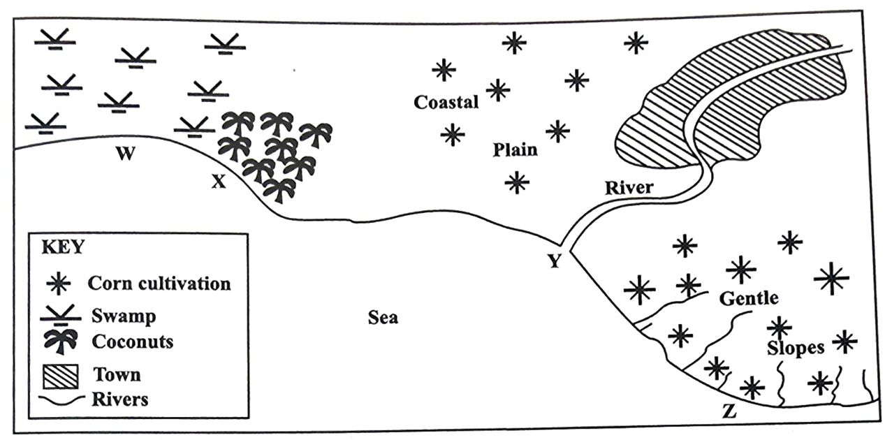
Items 41 and 42 are based on the following sketch map.
Water pollution is MOST likely to present a problem at
W
X
Y
Z
Which of the following is MOST likely to lead to a high level of water pollution along the coast?
Flooding of the swamp
Clearing of coconut trees
Growing of corn on the slopes
Releasing domestic waste from the town
Which of the following practices may help to sustain the marine environment in the Caribbean?
Zoning of marine activities
The development of ports and marinas
Harvesting of coral formations for souvenirs
Discharging sewage and industrial waste along the shore
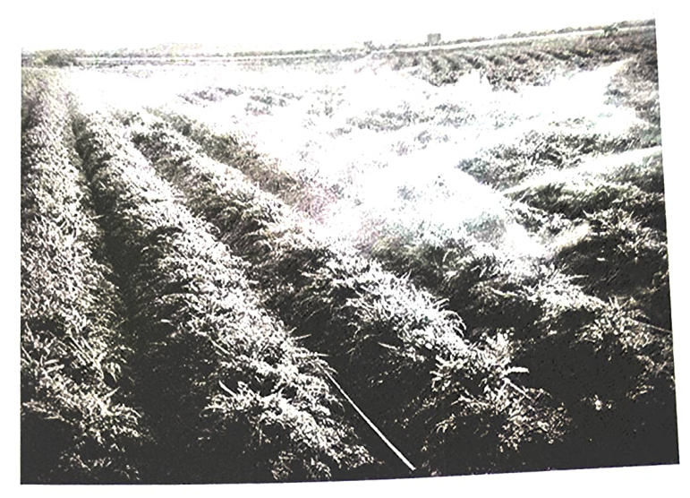
To what type of farming is the activity shown in the photograph MOST likely related?
Mixed cropping
Peasant farming
Commercial arable
Commercial pastoral
The rate of natural increase of a population is determined by
birth and death rates
birth rates and migration
death rates and emigration
birth rates and immigration
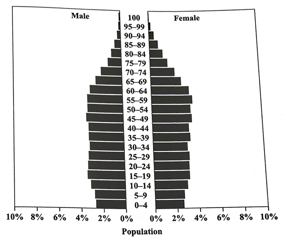
Which of the following statements is true of the country's population?
There is a high mortality rate.
The average lifespan is getting shorter.
There is a high ratio of dependents to workers.
There is a significant number of births each year.
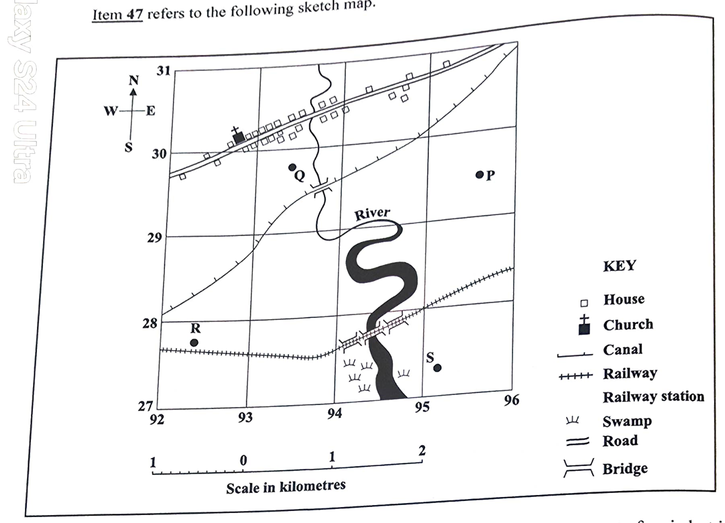
Which of the following sites would be MOST appropriate for the development of an industrial estate?
P
Q
R
S
Which of the following strategies is LEAST likely to promote the sustainable management of resources in the Caribbean?
Investing in eco-tourism initiatives
Developing initiatives for marine conservation
Implementing policies to reduce deforestation
Promoting the expansion of the manufacturing sector
Which of the following statements is true of small-scale farming?
Yields per farmer are generally high.
More than one crop is usually produced.
Large amounts of fertilizers are used on the farm.
Crop cultivation is not as important as animal rearing.
Which of the following activities is considered a poor farming practice?
Overgrazing
Crop rotation
Strip cropping
Contour ploughing
Which of the following Caribbean countries is known for its extensive mining of limestone?
Belize
St Kitts
Jamaica
Trinidad and Tobago
Which of the following is the MAIN renewable energy resource used in the Caribbean?
Solar
Wind
Tidal
Geothermal
Which of the following is an effect of preserving mangrove wetlands on the coast?
Ease in building ports
Smoothness of the coastline
Reduced erosion of the coastline
Increased erosion of the coastline
Which of the following consequences BEST represent(s) X?
Flooding
Landslides
Reduced rainfall
Decreased canopy
What other consequence can result from tropical deforestation?
Loss of flora
Increase in fauna
Decrease in lumbering
Increase in underground water
Which of the following is classified as a tertiary industry?
Fishing
Tourism
Oil refining
Food processing
Which of the following could contribute to the degradation of the environment?
Crop rotation
Use of manures
Use of chemical fertilizers
Controlling pests biologically
Which of the following measures do governments use to influence the development of industries?
Increasing property and sales taxes
Establishing industrial estates and parks
Offering training programmes to employees
Requiring environmental clearance certificates
Which of the following factors exert the GREATEST influence on tourism?
Climates
Coral reefs
Historical sites
Tropical forests
Which of the following factors has LEAST contributed to the decline in agriculture in many Caribbean territories?
Increase in global competition
Poor quality of crops produced
High cost of agricultural inputs
Removal of preferential trade agreements