Free CXC Geography Paper 1 May/June 2011 past paper from 2011. Includes a worked answer key. Open the PDF, take a timed test, and study with AI on Caribbean AI.
Answer keys are free on Caribbean AI. View the answers to every past-paper question at no cost - no payment needed - with step-by-step worked solutions and instant AI marking available on Premium.
CSEC Geography Paper 1 May/June 2011 - Free CXC Past Paper with Answers
Free CXC Geography Paper 1 May/June 2011 past paper from 2011. Includes a worked answer key. Open the PDF, take a timed test, and study with AI on Caribbean AI.
Opening the interactive papers…
Every question from this paper as text. See the answers and worked solutions. Questions are the property of the Caribbean Examinations Council; Caribbean AI is not affiliated with CXC.
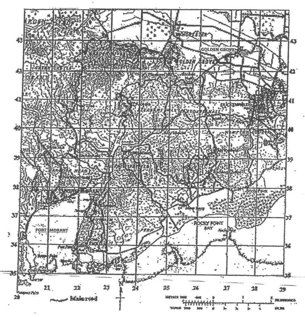
Items 1-3 refer to the following map.
What is the grid reference of the school (Sch) at Golden Grove?
273426
287434
426273
434287
The general direction of Port Morant from Golden Grove is
northeast
northwest
southwest
southeast
The bearing of the main road junction at Golden Grove from the Arcadia Junction (north of Northing 39) is APPROXIMATELY
045°
132°
228°
312°
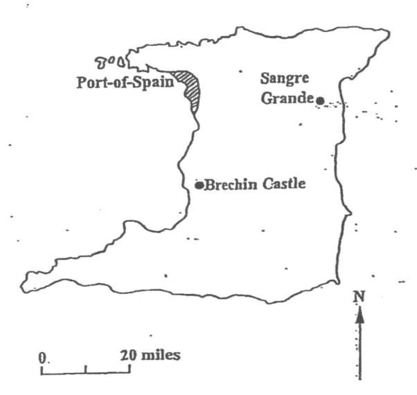
Item 4 refers to the following map. [Map of Trinidad showing Port-of-Spain, Sangre Grande, and Brechin Castle, with a scale of 20 miles and a North arrow.]
The straight-line distance between Brechin Castle and Sangre Grande is APPROXIMATELY
25 miles
35 miles
45 miles
55 miles
A scale of 1 : 10 000 on a map would indicate that
the map is 10 000 times larger than the ground it represents
1 unit on the map represents 10 000 units on the ground
1 inch on the map represents 10 000 feet on the ground
1 inch on the map represents 10 000 miles on the ground
The feature shown at X on the photograph above is a
cliff
point
stack
stump
Which ot the following will MOST likely produce the feature Y?
Wave erosion
Wave deposition
Wave reflection
Wave refraction
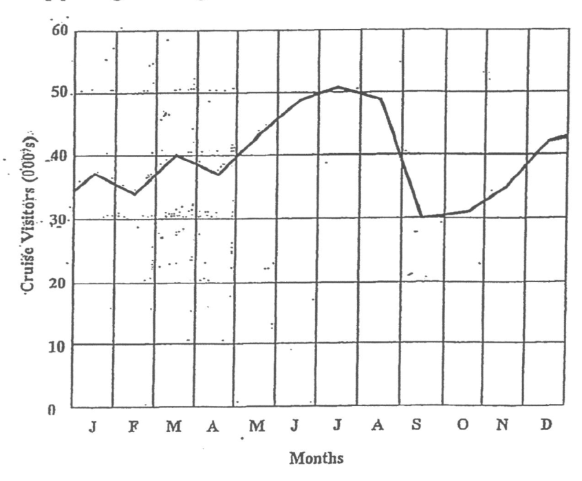
Items 8-9 refer to the following graph which shows variations in cruise ship passengers visiting a Caribbean island in 1989.
The LOWEST number of visitors in any month was
3 000
3 500
30 000
30 500
The LARGEST number of visitors arrive during
spring
summer
autumn
winter
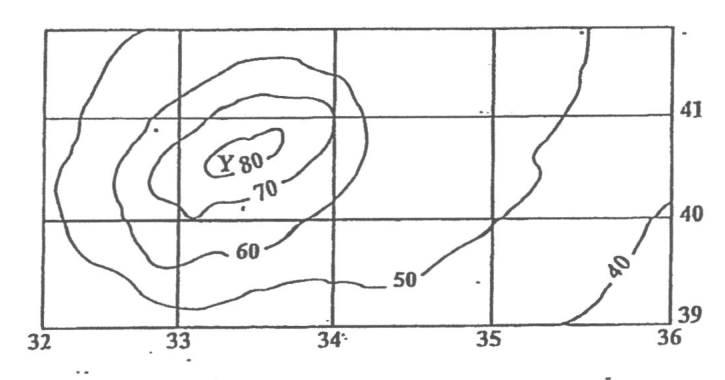
Items 10-11 refer to the following diagram.
The landform shown at Y is a
hill
ridge
valley
plateau
The contour interval, in metres, in the diagram above is
10
20
30
40
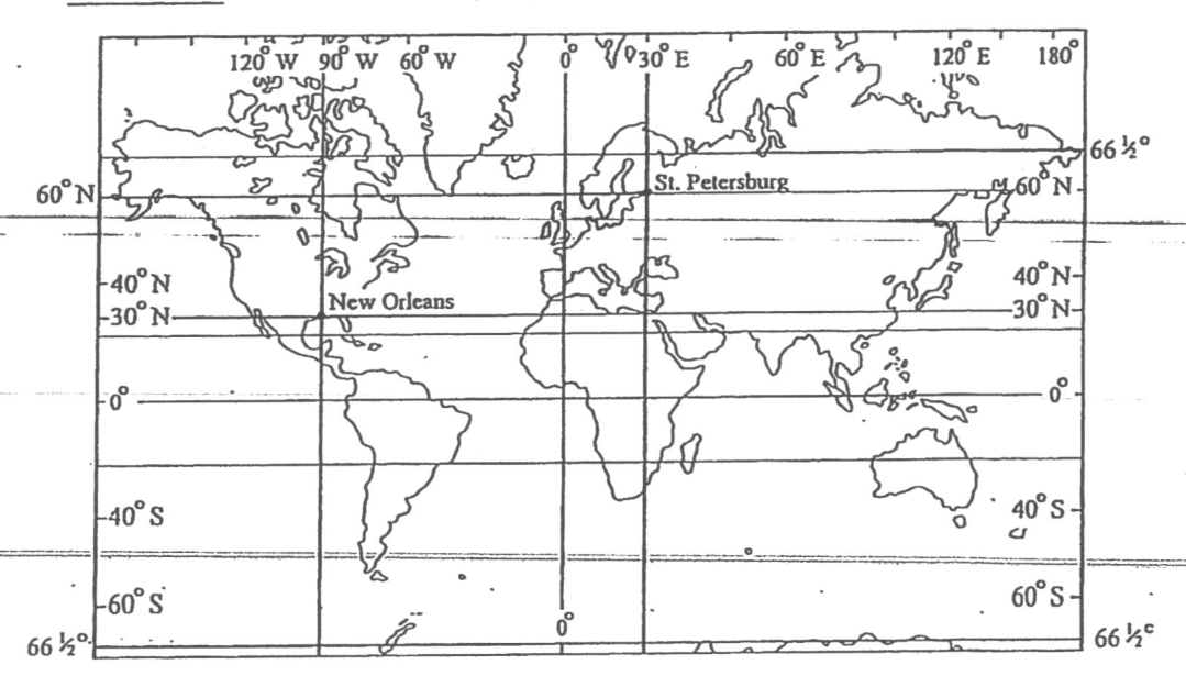
Items 12-13 refer to the following map.
What is the location of St. Petersburg?
30N 60E
30N 60W
60N 30W
60N 30E
What time is it in New Orleans when it is 10.00 p.m. on Monday in St. Petersburg?
2.00 p.m. Sunday
2.00 a.m. Sunday
2.00 p.m. Monday
2.00 a.m. Monday
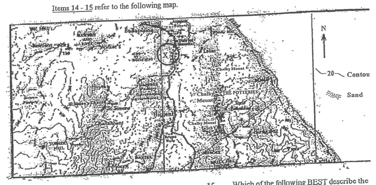
Items 14-15 refer to the following map.
The settlement pattern at X is
compact
dispersed
linear
nucleated
Which of the following BEST describe the stretch of coastline?
I and II only
II and III only
I and III only
I, II and III
Which of the statements below are true of MOST hurricanes? I. They are calm in their centre. II. They move across the Atlantic Ocean. III. They originate in the ITZC. IV. They decrease in strength overland.
I, II and III only
I, II and IV only
II, III and IV only
I, II, III and IV
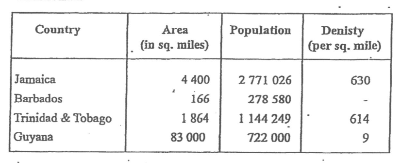
Barbados has a population density of ap- proximately
100
166
1 678
2788
A comparison of the population densities in the table above shows that
Guyana has approximately the same density as Trinidad and Tobago
Guyana has a higher density than Jamaica
Barbados has a lower density than Jamaica
Barbados has a higher density than Guyana
A correct relationship between longitude and time is that the time changes by
4 minutes for 1°
1 minute for 4°
1 hour for 20°
24 hours for 180°
Under which of the conditions shown above would the flow of a river vary MOST from season to season?
I and II only
I and III only
II and III only
II and IV only
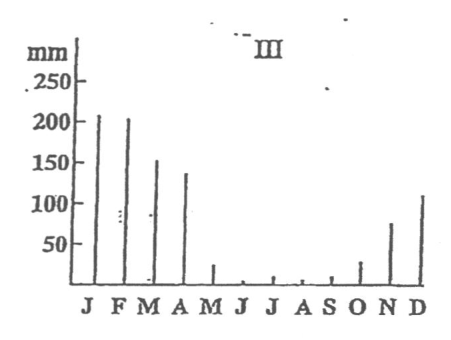
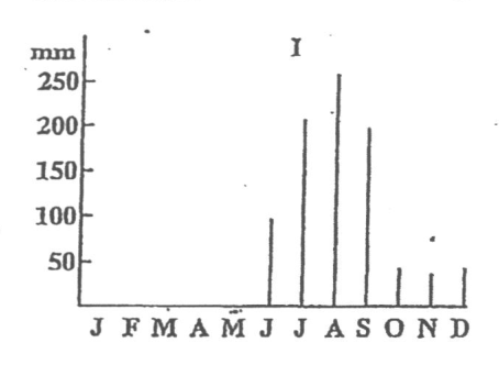
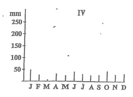
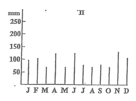
Which of the graphs above shows the GREATEST variation in rainfall?
I
II
III
IV
Which of the following are problems associated with urbanization in the Caribbean? I. Lack of adequate housing and services II. Poor public transport III. Decentralisation of shopping facilities IV. Unemployment and under-employment
I and II only
I, II and III only
I, II and IV only
I, II, III and IV
Which of the following BEST explain why the prairie environment is well suited to commercial arable farming? I. Flat or gently undulating land II. Deep, rich soil III. Cold, dry winters IV. Accessibility to markets
I, II and III only
I, II and IV only
I, III and IV only
II, III and IV only
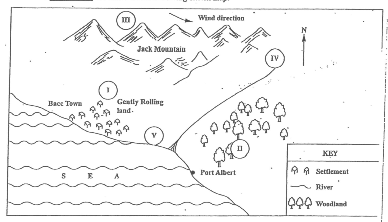
Which of the following would be the BEST area to locate a new factory in order to minimize the effects of air pollution?
I
II
III
IV
Which area could MOST LIKELY be developed as a tourist resort?
I
II
IV
V
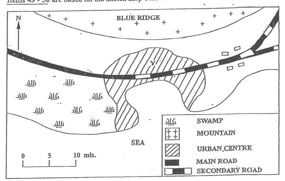
Items 49-50 are based on the sketch map below.
Which of the following BEST explain why the urban centre in the sketch map above is located at Y? I. The presence of a natural harbour II. The presence of flat land III. The nearness to the mountains
I and II only
I and III only
II and III only
I, II and III
In which direction is the urban centre MOST likely to expand?
North
South
East
West
Which of the following has NOT resulted from the setting up of secondary (manufacturing) industries in the Caribbean?
Reduction in the importation of consumer goods
Increased exports
Increased employment opportunities
Reduced cost of living
Which of the following exert the GREATEST influence on tourism in the Caribbean?
Carnivals
Coral reefs
Tropical forests
Climates
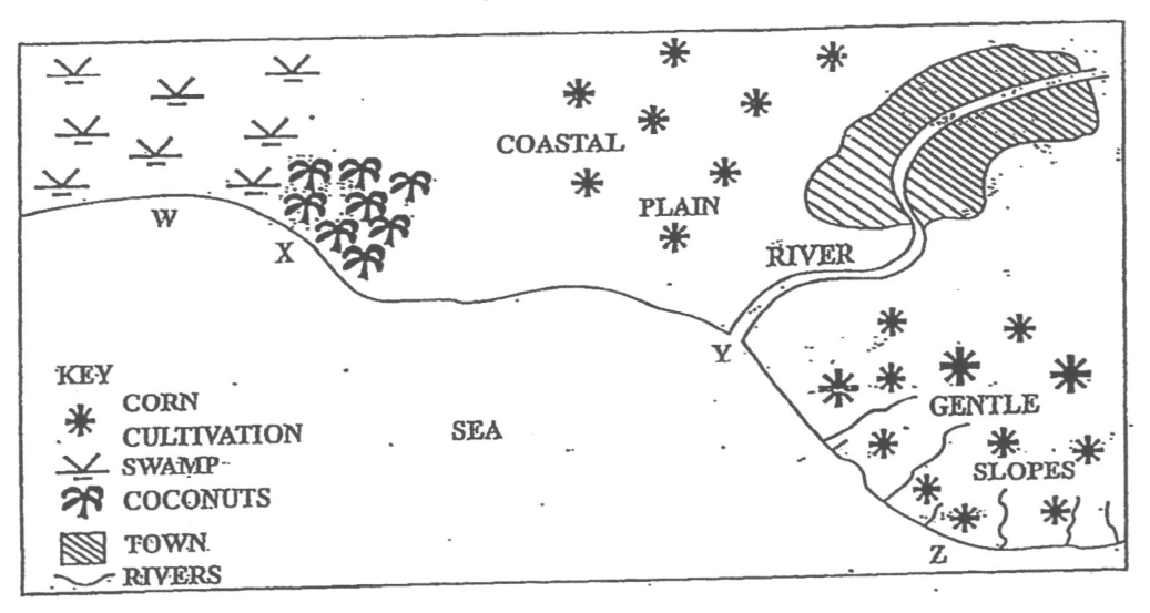
Items 53-55 are based on the sketch map below.
Water pollution is MOST likely to present a problem at
W
X
Y
Z
Which of the following factors is MOST likely to lead to a high level of water pollution along the coast shown above?
The lack of tidal currents
Improper disposal of domestic waste
The flatness of the land
The growing of corn on the slopes
Which of the following will control water pollution along the coast shown on the map?
I and II only
I and III only
I, II and IV only
I, III and IV only
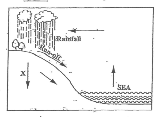
Item 56 refers to the diagram below.
In the diagram, X represents
transpiration
precipitation
percolation
evaporation
Which of the following is a form of air pollution?
Mercury poisoning
Oil spill
Raw sewage
Smog
Which of the following poses the MOST serious threat to water quality in the rivers of the Caribbean?
Activities by tourists
Flooding from hurricanes
Improper fishing practices
Dumping of waste
Which of the following practices may help to eliminate problems of pollution created by household waste?
Burying and covering with soil
Depositing in the sea
Dumping along water courses
Placing up in secluded spots
"Algae, nourished by waters enriched with nutrients, grow in abundance over the corals causing them to die." The situation described above can come about through
oil pollution
dredging and mining
fishing and dynamite
sewage discharge