Free CXC Geography Paper 2 May/June 2005 past paper from 2005. Includes a worked answer key. Open the PDF, take a timed test, and study with AI on Caribbean AI.
Answer keys are free on Caribbean AI. View the answers to every past-paper question at no cost - no payment needed - with step-by-step worked solutions and instant AI marking available on Premium.
CSEC Geography Paper 2 May/June 2005 - Free CXC Past Paper with Answers
Free CXC Geography Paper 2 May/June 2005 past paper from 2005. Includes a worked answer key. Open the PDF, take a timed test, and study with AI on Caribbean AI.
Opening the interactive papers…
Every question from this paper as text. See the answers and worked solutions. Questions are the property of the Caribbean Examinations Council; Caribbean AI is not affiliated with CXC.
Use the map extract (Savanna-la-mar, 1 : 50 000) provided to answer this question.
[28 marks]
State the six-figure grid reference of the Negril Lighthouse.
[2 marks]
What is the length of the sand beach at Long Bay?
[2 marks]
What is the grid bearing of the runway of the Negril Airstrip near to Bloody Bay?
[2 marks]
What direction is the town of Grange Hill from the town of Savanna-la-mar?
[1 mark]
Identify TWO crops cultivated along or close to the A-Class road between Savanna-la-mar and Grange Hill.
[2 marks]
Figure 1, provided as an insert, shows a section along Eastings 10 across Negril Hill. The horizontal scale is the same as the map's scale. Consult the map extract and on Figure 1, label FOUR of the five arrows marking items along the profile.
[4 marks]
Describe, giving suitable examples, the distribution and the types of settlement in the area bordered by Northings 73 and 80, and Eastings 20 and 34.
[4 marks]
Study the landscape along the C-Class road between Eastings 12 and 13 from Northing 82 to Northing 87. Identify THREE landforms or landform features along the road.
[3 marks]
With reference to examples from the map, suggest FOUR reasons for the distribution of cultivated and natural vegetation in the area of the map.
[8 marks]
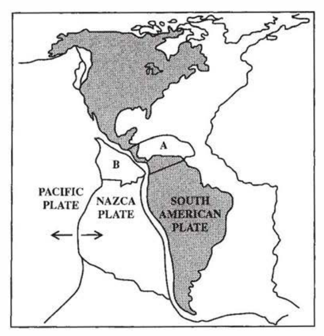
Use Figure 2 which shows some of the earth's tectonic plates to answer the following:
[24 marks]
Name the plate marked A.
[1 mark]
Name the plate marked B.
[1 mark]
What type of plate boundary is formed where the Pacific and Nazca plates meet?
[1 mark]
Define the term 'crustal plate'.
[1 mark]
Draw a diagram to show a normal fault. Label the fault plane and state how this type of fault is formed.
[3 marks]
State TWO benefits of volcanic activity to man.
[2 marks]
Name and state the location of ONE active volcano in the Caribbean.
[1 mark]
Explain how new crust is formed at constructive plate margins.
[3 marks]
How can the characteristics of lava lead to differences in the shapes of volcanic cones?
[4 marks]
Explain TWO ways in which rift valleys may be created.
[4 marks]
Why is the study of plate tectonics important?
[3 marks]
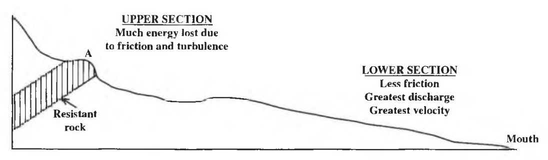
Use Figure 3, showing the long profile of a river, to answer the following questions:
[24 marks]
Where is friction at its GREATEST?
[1 mark]
Which section of the river has the GREATEST energy?
[1 mark]
Name the feature which may develop at A.
[1 mark]
Draw diagrams to show the following drainage patterns and state where EACH may develop: a) Radial b) Dendritic c) Trellis
State ONE condition necessary for deltas to form.
[1 mark]
Explain why deforestation and urbanization may lead to flooding.
[6 marks]
Explain TWO ways in which farming can lead to the destruction of coral reefs.
[4 marks]
Explain how coral reefs are important to beaches.
[4 marks]
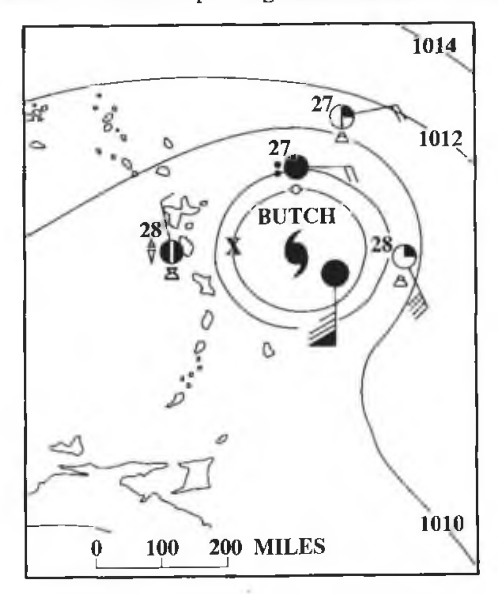
Use the Caribbean weather map in Figure 4 to answer the following:
Source: Macpherson, Introducing Caribbean Weather Maps, Pearson Education Ltd, 2000, p. 21.
[24 marks]
What is the MOST significant weather feature affecting the Eastern Caribbean?
[1 mark]
What is the atmospheric pressure at X?
[1 mark]
How many named weather systems had developed that year up to and including 'Butch'?
[1 mark]
Name the instruments used for measuring the following: a) Wind speed b) Atmospheric pressure c) Relative humidity
What is meant by 'relative humidity'?
[2 marks]
Where and how should a rain gauge be placed for accurate recording of rainfall?
[2 marks]
Using an annotated diagram ONLY, explain how sea breezes develop.
[3 marks]
With the use of appropriate examples, explain how relief helps to account for the differences in rainfall experienced in the Caribbean.
[5 marks]
Explain why temperatures in the Caribbean are different from those experienced in the Canadian Prairies.
[6 marks]
An insert, Figure 5, Map of the world, is provided for Question 5 (a).
[24 marks]
On the map of the world provided in Figure 5, outline and name ONE area where EACH of the following may be found:
Tropical rainforest
[1 mark]
Tropical grassland
[1 mark]
Temperate coniferous forest
[1 mark]
Name the type of soil typically found in areas of equatorial forests and identify any TWO characteristics of this soil.
[3 marks]
For equatorial climatic regions, state TWO characteristics of EACH of the following: a) Temperature b) Rainfall
[4 marks]
Explain why there is generally sparse vegetation on the floor of equatorial forests.
[2 marks]
Choose any THREE characteristics of the vegetation of coniferous forests and explain how EACH helps the trees to adapt to their environment.
[6 marks]
Explain the presence of trees in tropical grasslands.
[3 marks]
Explain how deforestation can lead to the rapid loss of soil fertility in equatorial areas.
[3 marks]
Draw a profile to show any THREE characteristics of a rendzina soil.
[3 marks]
State THREE characteristics of the rainfall of Tropical Marine Climates.
[3 marks]
Describe the amount, types and distribution of precipitation associated with Cool Temperate Interior Climates.
[4 marks]
Give TWO reasons why mangrove trees are able to survive in their environment.
[2 marks]
Explain how any TWO farming practices other than clearance of vegetation may lead to soil erosion.
[4 marks]
Give TWO reasons why it is important to conserve mangrove vegetation.
[4 marks]
Explain the role precipitation plays in the development of soils.
[4 marks]
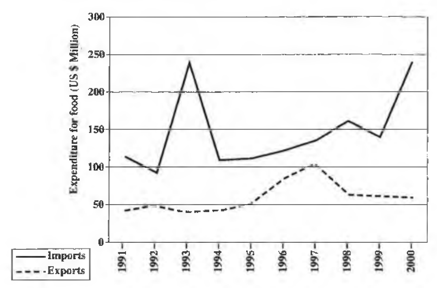
Study the graph in Figure 6 and answer the questions below.
In which year, between 1991 and 1999, did the MAXIMUM expenditure for food imports occur?
[1 mark]
Estimate the maximum expenditure in (a) (i) above.
[1 mark]
In which year was the difference in expenditure for food imports and food exports the LOWEST?
[1 mark]
Identify ONE area in the Caribbean where EITHER beef cattle rearing OR dairy farming is important.
[1 mark]
For EITHER beef cattle rearing OR dairy farming, describe THREE problems farmers encounter.
[6 marks]
Distinguish between 'primary industry' and 'secondary industry'.
[2 marks]
Give THREE reasons why some Caribbean countries are keen to protect their forest resources.
[3 marks]
Compare fishing in the Caribbean with that in British Columbia (Canada) under the following headings: a) Fishing methods b) Conservation methods c) Marketing
[6 marks]
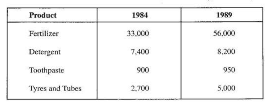
Table 1 shows the production level (in tonnes) of import - substitution manufacturing in Jamaica. Study Table 1 and answer the questions that follow.
| Product | 1984 | 1989 |
|---|---|---|
| Fertilizer | 33,000 | 56,000 |
| Detergent | 7,400 | 8,200 |
| Toothpaste | 900 | 950 |
| Tyres and Tubes | 2,700 | 5,000 |
Source: Sealey, Caribbean World - A Complete Geography, Cambridge University Press, 1993, p. 166.
Which product increased by 800 tonnes during the period 1984 - 1989?
[1 mark]
Which product had the HIGHEST production in 1989?
[1 mark]
What was the production level of tyres and tubes in 1989?
[1 mark]
A map is provided for this question in Figure 7 on the insert.
Use the sketch map, of the North-Eastern USA, provided in Figure 7 and insert the name of EACH of the THREE industrial centres indicated by a dot.
[3 marks]
Draw a sketch map of a named Caribbean territory and on it show a major industrial area and ONE other feature to show its location.
[4 marks]
Explain the difference between an 'import-substitution industry' and an 'enclave industry'.
[4 marks]
For EITHER an enclave OR an import substitution industry that you have studied in the Caribbean, explain TWO factors that have contributed to its location and development.
[4 marks]
Give THREE reasons why EITHER the North-Eastern USA OR the Lower Ganges Valley has grown into an important industrial area.
[6 marks]
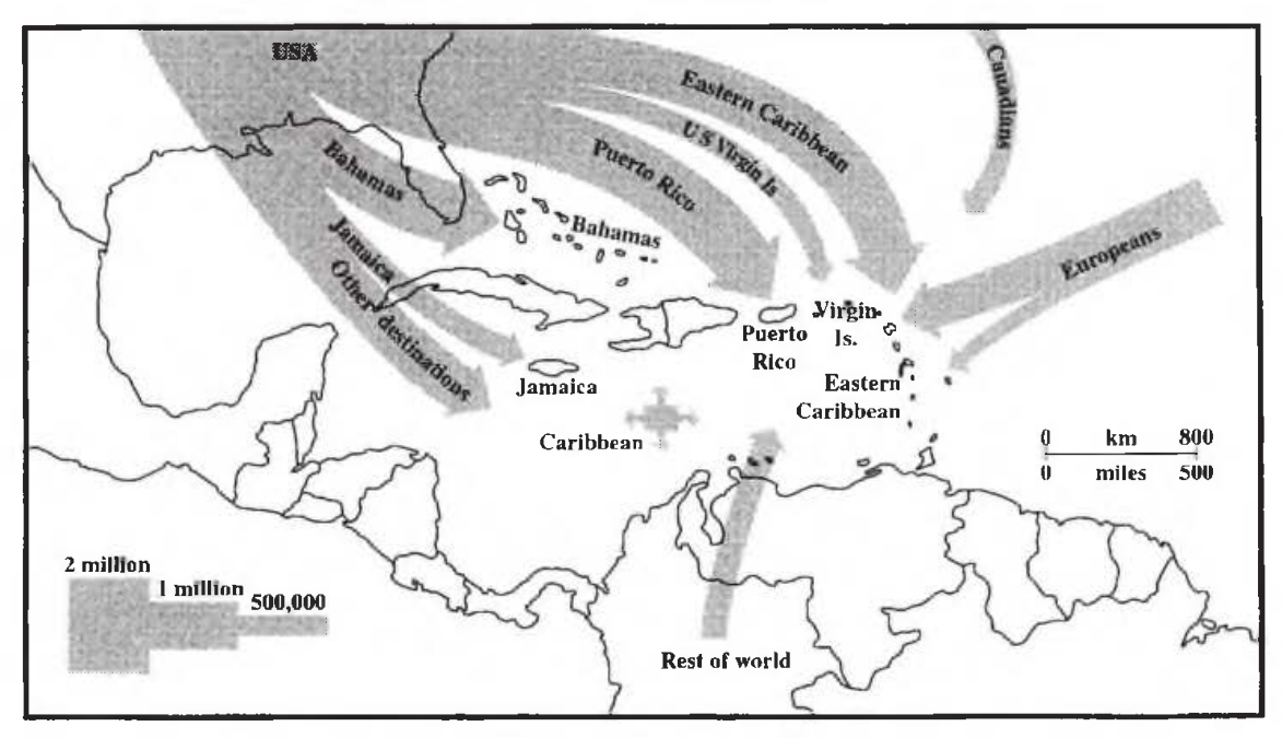
Study the map provided in Figure 8 on the origin of visitors to the Caribbean during a particular year and then answer the following questions:
Source: Sealey, Caribbean World - A Complete Geography, Cambridge University Press, 1993, p. 180.
How many visitors went to Jamaica from the USA during that year?
[1 mark]
Name ONE of the main destinations of visitors from the USA.
[1 mark]
Name the MAIN source of visitors to the Eastern Caribbean.
[1 mark]
List THREE ways in which seasonality affects the tourism industry in the Caribbean.
[3 marks]
Describe TWO ways in which tourism affects the environment.
[4 marks]
Explain the difference between 'secondary industry' and 'tertiary industry'.
[4 marks]
Explain how EACH of the following factors influences the growth of tourism in the Caribbean: a) Accessibility b) Government Policy
[8 marks]
Define the term 'ecotourism'.
[2 marks]
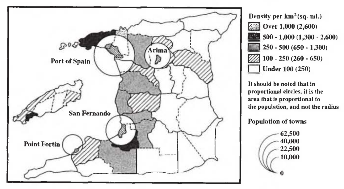
Study the choropleth map provided in Figure 9 which shows population distribution in Trinidad and Tobago and answer the following questions:
Source: Sealey, Caribbean World - A Complete Geography, Cambridge University Press, 1993, p. 196.
What is the population density of San Fernando?
[1 mark]
What is the HIGHEST population density?
[1 mark]
How many times is the population of Arima LARGER than the population of Point Fortin?
[1 mark]
List TWO traditional exports from the Caribbean. For ONE of the exports identified above, name ONE of the most important trading partners.
[3 marks]
For ONE of the exports identified above, name ONE of the most important trading partners.
[3 marks]
Describe TWO ways in which CARICOM aims at promoting regional trade.
[4 marks]
What is meant by the term 'urbanization'?
[2 marks]
Describe TWO factors that influence the selection of the site of the capital city of a named Caribbean country.
[4 marks]
Compare the growth and development of EITHER New York City OR Tokyo with that of a named Caribbean capital under the following headings: (i) Location (ii) Functions
[8 marks]