Free CXC Geography Paper 2 May/June 2026 past paper from 2026. Includes a worked answer key. Open the PDF, take a timed test, and study with AI on Caribbean AI.
Answer keys are free on Caribbean AI. View the answers to every past-paper question at no cost - no payment needed - with step-by-step worked solutions and instant AI marking available on Premium.
CSEC Geography Paper 2 May/June 2026 - Free CXC Past Paper with Answers
Free CXC Geography Paper 2 May/June 2026 past paper from 2026. Includes a worked answer key. Open the PDF, take a timed test, and study with AI on Caribbean AI.
Opening the interactive papers…
Every question from this paper as text. See the answers and worked solutions. Questions are the property of the Caribbean Examinations Council; Caribbean AI is not affiliated with CXC.
Study the map extract of St Christopher, Basseterre, drawn to a scale of 1:25 000 (provided as an insert), and answer the following questions.
[25 marks]
State the name of ONE river that flows through the town of Basseterre.
[1 mark]
State the six-figure grid reference of the trigonometrical station K9, which is located near Needsrnust Estate.
[2 marks]
State the direction of trigonometrical station K9 from trigonometrical station K5 (2314).
[1 mark]
Measure and state the bearing of the police station at Stapleton (2215) from the trigonometrical station K5 (2314).
[2 marks]
Measure and state, in kilometres, the length of the railway from Fort Smith (2411) to the junction where the railway meets the main road near Kit Stoddart's (2313).
[2 marks]
Use ONE of the following words to describe the slope of the land in the north-western section of the map extract.
Gentle, moderate, steep
[1 mark]
Figure 1 shows a grid section of the map extract of St Christopher, Basseterre, drawn to a scale of 1:25 000.
Using the symbols in the key, complete the grid by inserting the following. (i) An area of coral (ii) The location of a pond (iii) The course of the Bridge Gut river
[3 marks]
Identify THREE features of the road network between Eastings 19 and 22 that are shown on the map extract.
[3 marks]
Using examples, describe TWO characteristics of the drainage shown on the map extract.
[4 marks]
Using evidence from the map extract, explain how THREE physical factors have influenced the location/development of the town of Basseterre.
[6 marks]
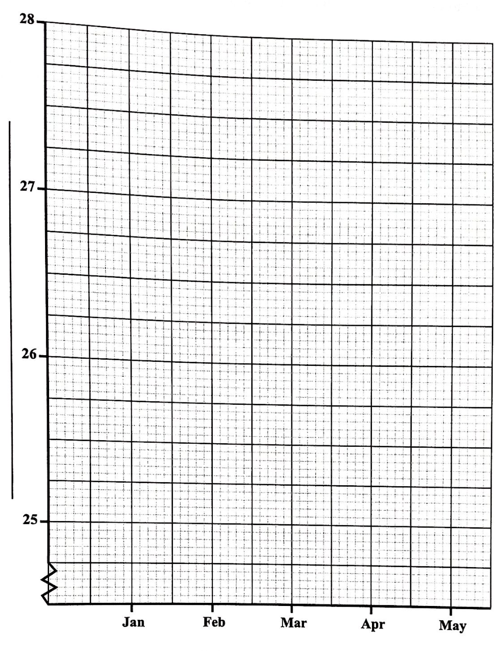
Table 1 shows the mean air temperature for an automated weather station in the Caribbean for a five-month period, during the dry season.
| Month | January | February | March | April | May |
|---|---|---|---|---|---|
| Mean Air Temperature (C) | 26.0 | 26.4 | 25.9 | 27.0 | 27.5 |
On the grid provided on page 9. (i) draw a line graph to illustrate the data presented in Table 1 (ii) provide a title for the graph (iii) label EACH axis correctly
[5 marks]
Define EACH of the following terms.
[4 marks]
Mass movement
[2 marks]
Soil creep
[2 marks]
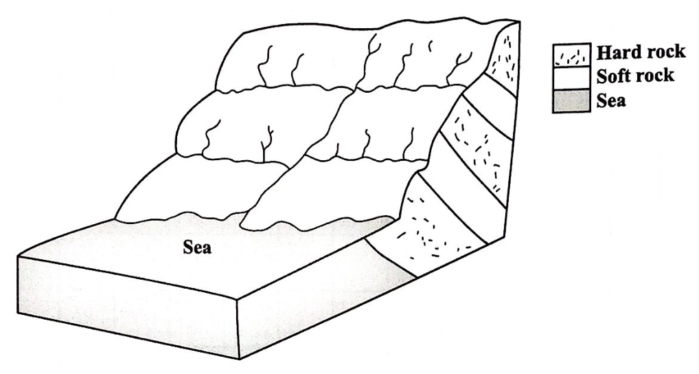
Figure 2 shows a diagram of a drainage pattern.
[4 marks]
Identify the type of drainage shown in Figure 2.
[1 mark]
On Figure 2, label EACH of the following features.
[3 marks]
Explain how EACH of the following drainage patterns can develop.
[6 marks]
Radial
[3 marks]
Dendritic
[3 marks]
Explain how an earthquake occurs at EACH of the following plate boundaries.
[6 marks]
Convergent plate boundaries
[3 marks]
Transform plate boundaries
[3 marks]
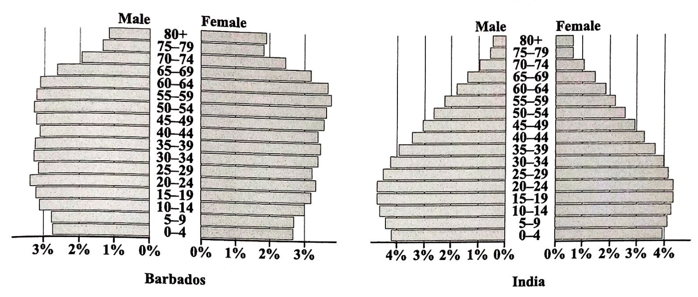
Figure 3 shows the 2022 population pyramids for Barbados and India.
Source: Retrieved 23 March 2024, from https://www.worlddata.info
(i) Which country has the higher proportion of its population in the 0–9 age group? (ii) Which country has the higher proportion of its population aged over 65? (iii) In Barbados, which age group over 49 represents the largest percentage of the population? (iv) In India, which age group represents the largest percentage of the population? (v) Which sex appears to be living longer in both countries?
[5 marks]
Which country has the higher proportion of its population in the 0–9 age group?
[1 mark]
Which country has the higher proportion of its population aged over 65?
[1 mark]
In Barbados, which age group over 49 represents the largest percentage of the population?
[1 mark]
In India, which age group represents the largest percentage of the population?
[1 mark]
Which sex appears to be living longer in both countries?
[1 mark]
Secondary and tertiary economic activities are vital components of the Caribbean's economy, contributing to diversification beyond traditional primary industries.
[8 marks]
Differentiate between secondary and tertiary economic activities.
[4 marks]
Name TWO Caribbean countries which are major producers of timber.
[2 marks]
Name ONE Caribbean country in which the mining of precious and semi-precious minerals, such as gold and diamonds, is done on a large scale.
[1 mark]
Name ONE Caribbean country which is NOT a major tourist destination.
[1 mark]
Explain how EACH of the following affects population growth in the Caribbean.
[6 marks]
Natural increase
[3 marks]
Life expectancy
[3 marks]
Explain how TWO of the following factors have prevented EITHER bauxite mining OR oil drilling in the Caribbean region.
[6 marks]
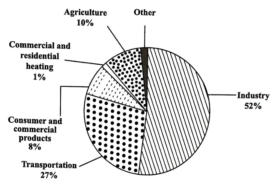
Figure 4 is a pie chart which shows the sources of air pollutants and the percentage emissions.
Source: Retrieved 6 November 2017, from https://www.researchgate.net/figure/Sources-of-Emissions-of-Air-Pollution-International-energy-resources-2011 fig1 313894270
What percentage of air pollutants does the agriculture sector account for?
[1 mark]
Which sector is responsible for 8% of air pollutants?
[1 mark]
What sector contributes the HIGHEST percentage of pollutants to the air?
[1 mark]
What percentage of air pollution is contributed by other sources?
[1 mark]
State ONE conclusion that can be drawn from the information given in the chart.
[1 mark]
Define the term 'natural disaster'.
[2 marks]
Describe THREE ways in which EITHER a hurricane OR an earthquake affects the physical and human landscape in densely populated areas.
[6 marks]
Explain how TWO measures used by local disaster preparedness agencies before the occurrence of a natural hazard in the Caribbean may help to reduce the impact of the hazard.
[6 marks]
Explain ONE way in which tourism may contribute to the degradation of EACH of the following environments.
Coral reefs
[3 marks]