Free CXC Geography Paper 2 May/June 2025 past paper from 2025. Includes a worked answer key. Open the PDF, take a timed test, and study with AI on Caribbean AI.
Answer keys are free on Caribbean AI. View the answers to every past-paper question at no cost - no payment needed - with step-by-step worked solutions and instant AI marking available on Premium.
CSEC Geography Paper 2 May/June 2025 - Free CXC Past Paper with Answers
Free CXC Geography Paper 2 May/June 2025 past paper from 2025. Includes a worked answer key. Open the PDF, take a timed test, and study with AI on Caribbean AI.
Opening the interactive papers…
Every question from this paper as text. See the answers and worked solutions. Questions are the property of the Caribbean Examinations Council; Caribbean AI is not affiliated with CXC.
Study the map extract of Pointe Michel, Lesser Antilles, drawn on a scale of 1:25 000 (provided as an insert), and answer the following questions.
[25 marks]
State the height of the trigonometrical station (6586) in the town of Pointe Michel.
[1 mark]
Name ONE social service provided for the population of the town of Pointe Michel.
[1 mark]
State the six-figure grid reference of the school at Scotts Head Village (Cachacrou) in the southern section of the map extract.
[2 marks]
State the compass direction of the trigonometrical station (6981) from the school at Scotts Head Village (6781).
[1 mark]
Measure and state the bearing of the police station in Soufriere (6783) from the school at Tete Morne (6983).
[2 marks]
Measure and state the distance along the surfaced road (main road) from Trigonometrical Station 8 near Scott's Head Village to the police station in Soufriere (6783) along Soufriere Bay. Give your answer to the nearest hundred metres.
[2 marks]
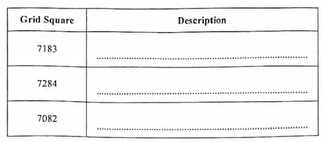
Complete the table below by using the words from the list to describe the slope of the land at EACH of the following locations on the map.
Gentle, moderate, steep
| Grid Square | Description |
|---|---|
| 7183 | |
| 7284 | |
| 7082 |
[3 marks]
Identify THREE features of the site of the town of Soufriere.
[3 marks]
Describe TWO features of the road network on the map extract west of Easting 69.
[4 marks]
Outline THREE ways in which the relief of the land has influenced land use south of Northing 84 on the map extract. Use appropriate examples to support your responses.
[6 marks]
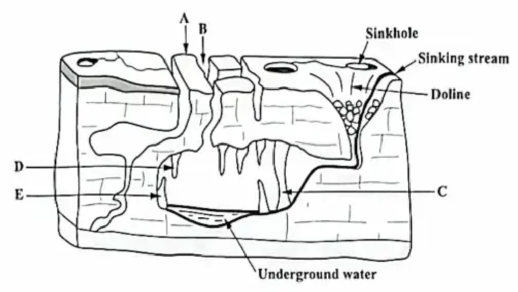
Figure 1 shows the cross-section of a limestone landscape. Study the figure and answer the questions that follow.
Name EACH of the features labelled A–E in Figure 1.
[5 marks]
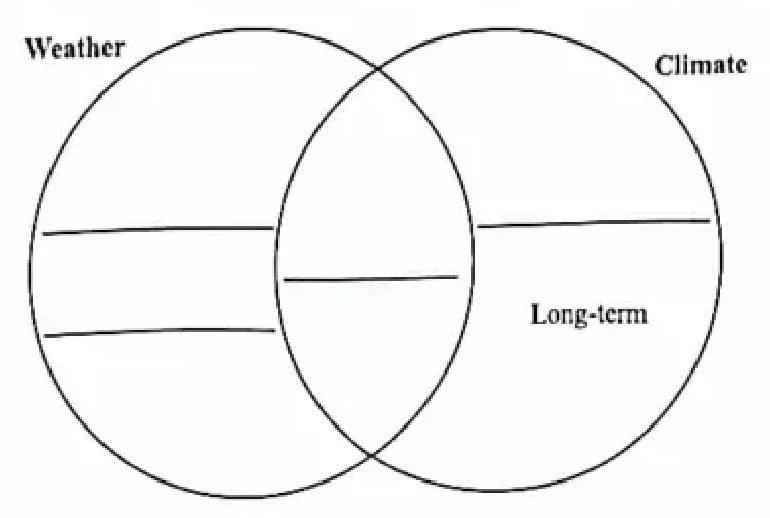
Complete the Venn diagram below by writing the terms associated with weather and/or climate in the correct positions. 'Long-term' has been included in the diagram as an example.
Temperature, predictable, unpredictable, short-term, longitude
[4 marks]
Define the following terms.
Permeable rock
Weathering
[4 marks]
The Cockpit Country in Jamaica is known to have a high level of biodiversity, but under this area is a unique karst landscape with various features.
Explain TWO of the following features are formed in a karst landscape.
[6 marks]
Explain THREE ways in which precipitation in a tropical marine climate differs from that in an equatorial climate.
[6 marks]
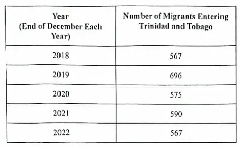
Table 1 shows the number of migrants entering Trinidad and Tobago between 2018 and 2022. Study the table and answer the questions that follow.
| Year (End of December Each Year) | Number of Migrants Entering Trinidad and Tobago |
|---|---|
| 2018 | 567 |
| 2019 | 696 |
| 2020 | 575 |
| 2021 | 590 |
| 2022 | 567 |
Adapted from Helen Harris, Essential Math Skills, Ed. Heather Davis, Philip Allan for Hodder Education, 2016. Retrieved 31 March 2023, from https://www.hoddereducation.co.uk/media/Documents/Geography/Essential-Maths-Skills-For-Geography_Sample-Pages.pdf
[5 marks]
State the modal number of migrants entering Trinidad and Tobago.
[1 mark]
State the median number of migrants for the period.
[1 mark]
Calculate the mean number of migrants for the period. (Show all working.)
[3 marks]
With reference to migration, outline the difference between a push factor and a pull factor. Your answer should include an example of each.
[4 marks]
Describe TWO pull factors other than the one given in (b) (i) which have contributed to out-migration from the Caribbean region since the 1990s.
[4 marks]
Explain TWO benefits which are derived from primary sector activities in the Caribbean.
[6 marks]
Explain how any TWO economic factors have influenced the development of agriculture in the Caribbean.
[6 marks]
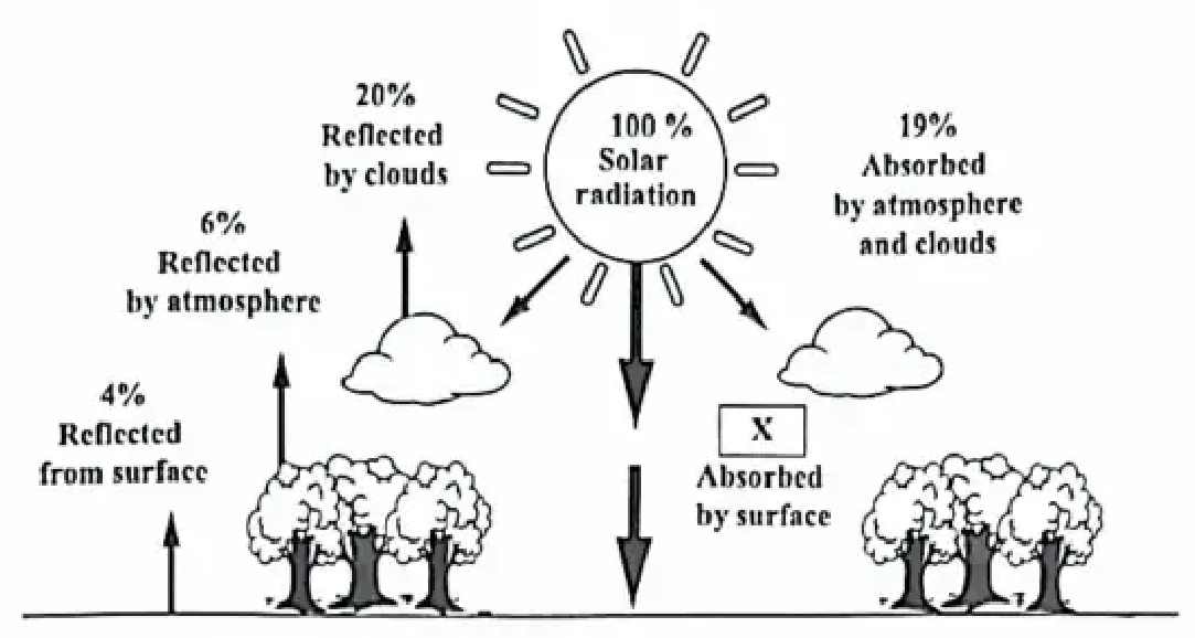
Figure 3 is a schematic diagram which shows the distribution of the incoming solar radiation. Study the diagram and answer the questions that follow.
Adapted from Pidwirny, M. (2006). Atmospheric Effects on Incoming Solar Radiation. Fundamentals of Physical Geography, 2nd Edition. Retrieved 29th March, 2023 from https://www.physicalgeography.net/fundamentals/7f.html
[25 marks]
State what happens to 19% of the incoming solar radiation.
[1 mark]
Determine the percentage of solar radiation that is reflected before it reaches the earth's surface.
[1 mark]
Determine the percentage of solar radiation that is reflected in total.
[1 mark]
Calculate the percentage of solar radiation that is absorbed at the Earth's surface, X. Show all working.
[2 marks]
Explain what is meant by the term 'global warming'.
[4 marks]
Describe TWO ways in which the clearing of land for arable farming contributes to global warming.
[4 marks]
Over the last 30 years, Caribbean countries have experienced an economic decline in the sugar industry. In order to manage this decline, countries have had to transform their economies and repurpose agricultural lands.
Explain TWO ways in which Caribbean countries have diversified land use in sugar producing areas. Use appropriate examples to support your responses.
[6 marks]
Explain TWO ways in which agriculture contributes to environmental degradation in the Caribbean.
[6 marks]